China has been plagued by floods in history, where the flood losses account for about 10% of the world. In recent years, under the impact of climate change, extreme weather events such as heavy rainstorms and severe precipitation have occurred frequently, increasing the frequency and intensity of fluvial floods. Meanwhile, as China and other other developing countries undergo rapid urbanization, cities’ exposure to fluvial flood is increasing year by year. For example, the “7/20” torrential rain in Zhengzhou and the heavy rainfall in North China in July 2023 resulted in heavy casualties and property losses to the Central Plains urban agglomeration and the Beijing-Tianjin-Hebei urban agglomeration respectively. Therefore, it is imperative to predict future fluvial flood risks of major urban agglomerations in China for disaster prevention and mitigation in our efforts to protect people's lives and property.
To address the above problem, Lu Hui’s Research Group of DESS, Tsinghua University uses the hydrological model Variable Infiltration Capacity (VIC) and the hydrodynamic model CaMa-Flood to generate a set of inundation maps of floods in different recurrence periods in China at about 500 m resolution. Then the Research Group uses the hydrodynamic model bias-corrected from the five CMIP6 model contributions to the latest phase 3b of the Inter-Sectoral Impact Model Intercomparison Project (ISIMIP3b) to obtain the scope of flood inundation under future climate change,
The study focuses on the urban agglomerations of Beijing-Tianjin-Hebei (BTH), Yangtze River Delta (YRD), Pearl River Delta (PRD), Central Plains (CP), Triangle of Central China (TCC), ChengduChongqing (CC), and Central Shanxi Plain (CSP). The inundated areas of fluvial floods generated are added to the future urban land projection products to obtain the projected data of future inundated urban land. The GDP and population of the seven urban agglomerations account for over one half of the GDP and population of China. Also, these agglomerations are located in the main floodplains of China, and may face high flood risk in the future. The research findings indicate that the inundated urban land areas in the future are projected to be 4 to 19 times that of the present (Fig. 1a). The future fluvial flood risk of southern agglomerations will be higher than that of northern agglomerations. Besides, in YRD, TCC and PRD urban agglomerations, particularly sharp rises in the area of inundated urban areas are projected after 2 °C warming. Therefore, for disaster prevention and mitigation, it is essential to restrict warming to below 2 °C.
It has been found in the study that even though climate change plays a dominant role in aggravating the future fluvial flood risk of urban agglomerations in China, yet without considering the urban spatial expansion, the inundated urban land areas will be underestimated by 10-50% (Figs. 1b and 1c). Therefore, considering urban expansion is of great significance to the risk prediction of future fluvial flood. In addition, the PRD urban agglomeration is highly developed, and the CC urban agglomeration is mountainous, so the future urban expansion will be kept far away from the river, and the risk of the newly-developed urban land will be less than that of the historical urban land. However, the marginal expansion pattern of urban agglomerations in BTH, CSP, CP and TCC will lead to newly-developed urban land being more vulnerable to inundation in the future (Fig. 2). Therefore, from the perspective of disaster prevention and mitigation, reasonable urban expansion is indispensable.
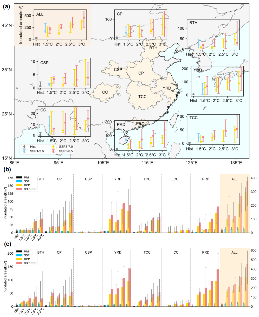
Fig. 1 The projected inundated urban land areas of the seven urban agglomerations. (a) 30-year average annual inundated urban land areas for the historical period (Hist) and future warming levels under different scenarios. The circles are the ensemble median projections, with the spread indicated by the ensemble minimum and maximum. (b) 30-year average annual inundated urban land areas of each urban agglomeration under different assumptions for SSP3-7.0. RCP means only climate change is considered, SSP means only urban land expansion is considered, and SSP-RCP means both climate change and urban expansion are considered. Bars are the ensemble median, with the spread indicated by the ensemble minimum and maximum. Histograms within the shaded background refer to the right-hand y-axis scale. (c) The same as (b), but under SSP5-8.5.
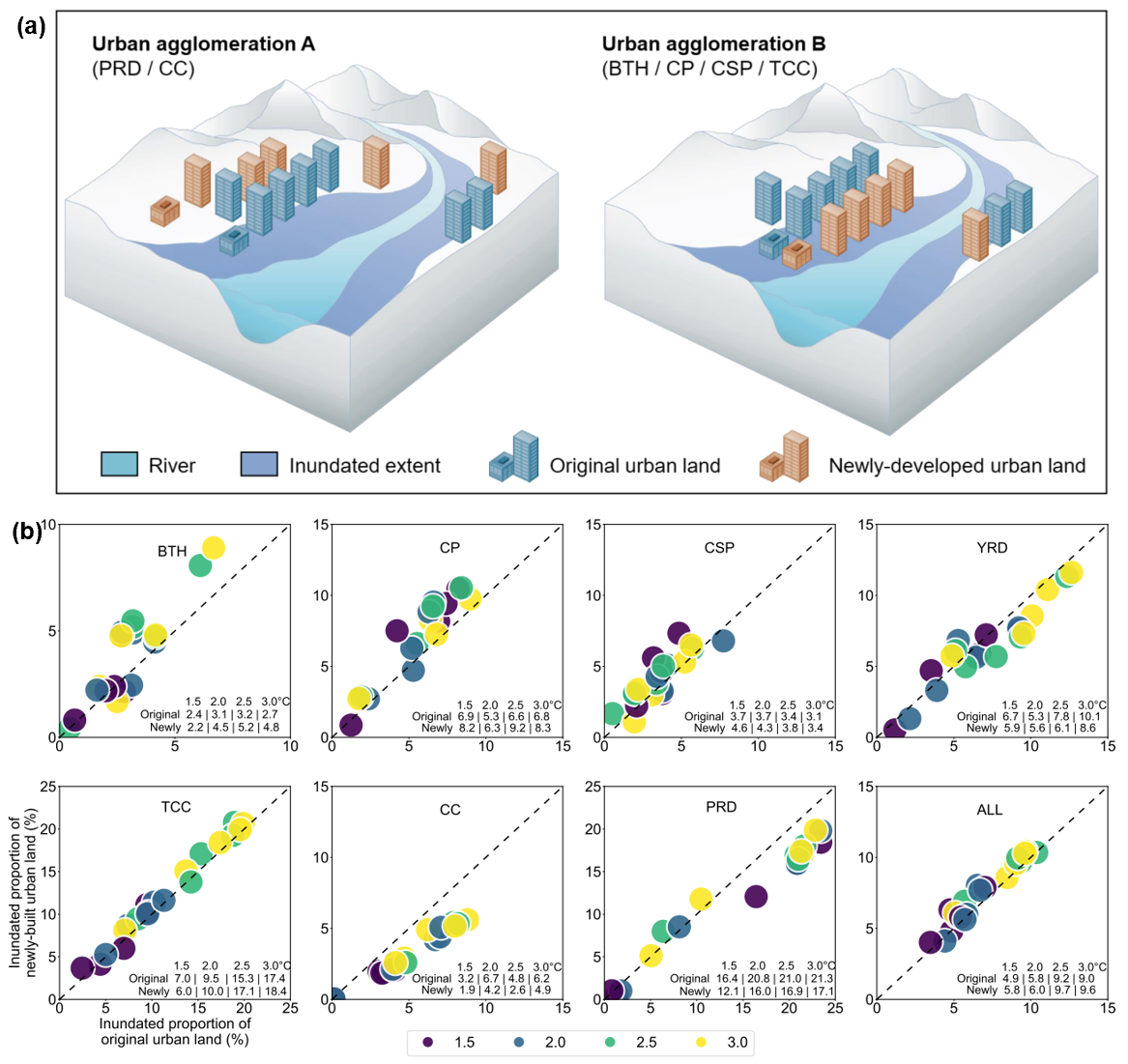
Fig. 2 The spatial distributions of original urban land in the historical period and newly-developed urban land in the future. (a) Impact of different urban expansion patterns on the fluvial flood risk of original urban land and newly-developed urban land in the future. (b) the scope of inundated urban land under the SSP5-8.5 scenario. The x-axis represents the original 30-year inundated urban land extent as a proportion of the total original urban land area, and the y-axis represents the 30-year inundated newly-developed urban land extent as a proportion of the total newly developed urban land area. The color of the dots represents the warming level. Each color has five dots, representing five GCMs. The values in the lower right represent the median inundated proportion based on the five GCMs.
The study systematically predicts the future fluvial flood risk of major urban agglomerations in China, providing a scientific basis for China to actively cope with climate change and extreme weather and prevent meteorological and hydrological disasters. Meanwhile, the study focuses on the impact of urban expansion on fluvial flood risk of urban land, which offers important inspiration and reference significance for formulating urban flood control standards, making urban spatial planning, coordinating responses to climate change and socioeconomic development. The study is also of reference significance to other developing countries undergoing rapid urbanization.
The related research results have been published in Communications Earth & Environment in the form of a paper titled “Substantial increase in future fluvial flood risk projected in China’s major urban agglomerations”. Jiang Ruijie, a Class 2000 doctoral student of the DESS, Tsinghua University, is the first author of the paper, and Professor Lu Hui of the DESS, Tsinghua University is the correspondent author. Other co-authors are from the DESS, Tsinghua University, the Department of Hydraulic Engineering, Tsinghua University, the University of Gothenburg in Sweden, the University of Tokyo in Japan and the University of California, San Diego. This work was jointly supported by the National Key Research and Development Program of China (2022YFC3002901), the Second Tibetan Plateau Scientific Expedition and Research Program (STEP, grant No. 2019QZKK0206), and the International Partnership Program of the Chinese Academy of Sciences (Grant No. 183311KYSB20200015).
Paper information:
Jiang, R., Lu, H., Yang, K. et al. Substantial increase in future fluvial flood risk projected in China’s major urban agglomerations. Commun Earth Environ 4, 389 (2023). https://doi.org/10.1038/s43247-023-01049-0
Full-text link: https://www.nature.com/articles/s43247-023-01049-0

Written by Jiang Ruijie
Edited by Wang Jiayin
Reviewed by Lu Hui and Zhang Qiang


 Picture News
 Hot News

