Geostationary meteorological satellites, with their high temporal resolution and capability for continuous wide-area observations, are widely used for surface solar radiation monitoring. However, existing geostationary satellite radiation products still suffer from a long-overlooked issue: terrain undulations cause the satellite’s actual observation position to deviate from the nominal pixel location, resulting in imperfect correspondence between the radiation information recorded by the satellite and the actual surface footprint. Professor Yang Kun’s research group from the Department of Earth System Science (DESS) at Tsinghua University conducted geolocation displacement correction for geostationary satellite pixels based on digital elevation models and satellite viewing geometry, and found that geolocation displacement introduces non-negligible systematic biases in the accuracy of solar radiation products over mountainous regions.
Terrain-induced pixel geolocation displacement is a typical problem in satellite remote sensing over complex terrain. This arises because geostationary satellite pixel geolocation typically assumes the Earth’s surface is an ellipsoid, whereas the actual surface has elevation variations, causing the satellite’s effective observation position to deviate from the nominal pixel location (Fig. 1a). Taking the Himawari-8 satellite as an example, in the high-elevation mountainous regions of western China, the displacement of its effective observation position relative to the nominal location can reach up to 30 km (Fig. 1b). However, existing Himawari-8-based radiation products generally do not fully account for the impact of this terrain-induced geolocation displacement. To what extent, then, does this geolocation error affect the accuracy of solar radiation retrieval?
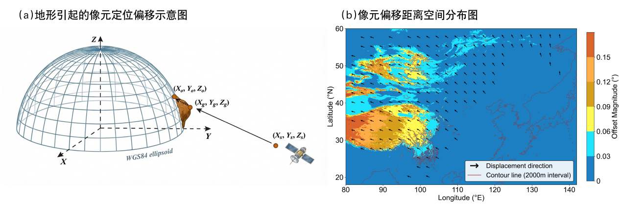
Fig. 1 Schematic of pixel geolocation displacement in geostationary satellite observations over complex terrain. (a) Schematic of satellite observation geometry, where subscript s denotes the satellite position, g denotes the nominal surface position determined based on the reference ellipsoid, and o denotes the actual observation position affected by terrain undulations; (b) Spatial distribution of pixel geolocation displacement distance for the Himawari-8 satellite, where arrows indicate displacement direction and color indicates displacement distance.
To address this question, the research group first performed pixel geolocation displacement correction on the Himawari-8 solar radiation product based on digital elevation models and satellite viewing geometry, and further validated the correction effect using the well-geolocated MODIS solar radiation product and radiation observations from China Meteorological Administration stations. The results show that after geolocation displacement correction, the accuracy of the Himawari-8 solar radiation product is significantly improved. Over the Qinghai–Tibet Plateau (MODIS tile: h25v05), the spatial root-mean-square difference (RMSD) between the corrected solar radiation and MODIS solar radiation decreased by 28.5 W m⁻⟡, and the correlation coefficient (R) increased by 0.11 (Fig. 2). Evaluation based on station data also demonstrated improved accuracy of the corrected radiation data. Further analysis revealed that the error caused by geolocation displacement is closely related to both the displacement distance and the spatial heterogeneity of local solar radiation: the greater the spatial displacement, or the more pronounced the local spatial variation in radiation, the more significant the impact of geolocation displacement on radiation product accuracy.
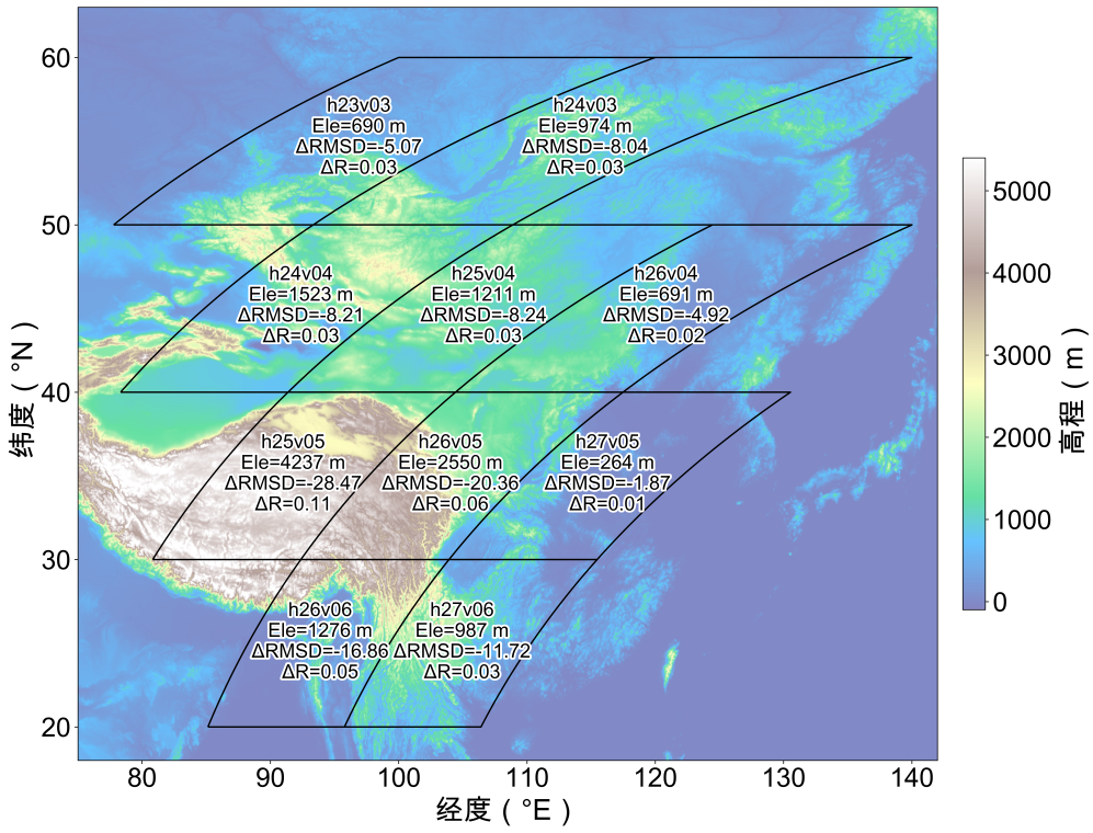
Fig. 2 Correction effect of geolocation displacement on the Himawari-8 solar radiation product over different MODIS tile regions. The figure shows the changes in consistency between Himawari-8 and MODIS observations before and after correction for each tile region (denoted as hxxvxx) in 2017, where ΔRMSD and ΔR represent the improvement in root mean square difference and correlation coefficient, respectively, and Ele denotes the regional average elevation.
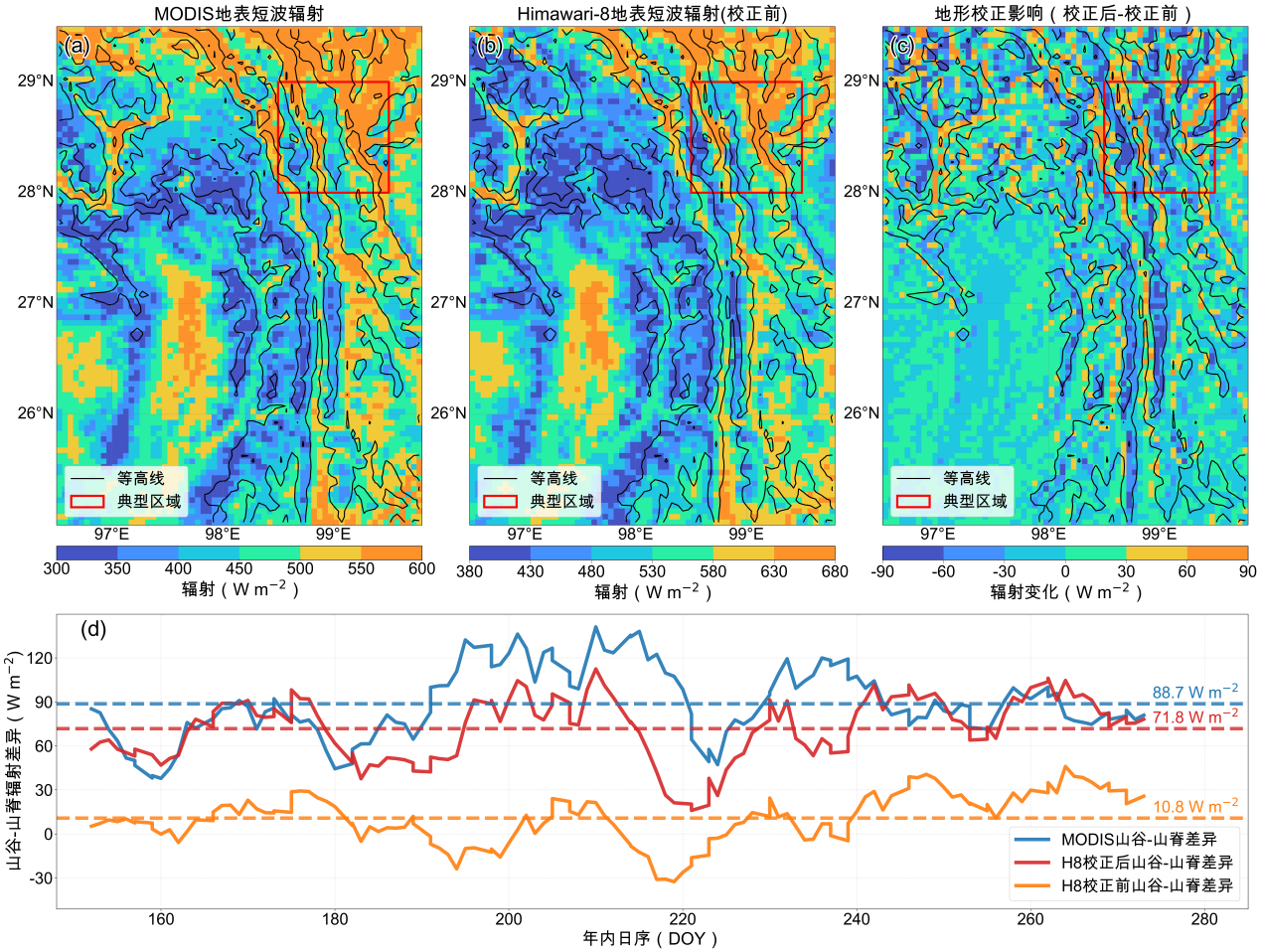
Fig. 3 Comparison of spatial distribution and geolocation displacement correction effect between MODIS and Himawari-8 solar radiation products over complex terrain in the Hengduan Mountains region. (a) MODIS solar radiation product; (b) Himawari-8 solar radiation product without geolocation displacement correction; (c) Difference between corrected and uncorrected Himawari-8 solar radiation products (corrected − uncorrected). Black contour lines represent terrain elevation, and the red box denotes the valley–ridge radiation difference analysis area. (d) Changes in valley–ridge radiation difference over a typical area during the warm season of 2017, where the three dashed lines represent the warm-season average differences for MODIS, corrected Himawari-8, and uncorrected Himawari-8 products, respectively.
The research group further revealed the special impact of geolocation displacement correction over complex terrain regions. Taking the Hengduan Mountains as an example, the MODIS solar radiation product shows low radiation over ridges and high radiation over valleys, with pronounced spatial differences (Fig. 3a). In contrast, uncorrected Himawari‑8 solar radiation products display a spatial pattern across valleys and ridges that differs substantially from the MODIS products (Fig. 3b). After geolocation displacement correction, the spatial distribution of Himawari-8 solar radiation improved, with radiation values decreasing over ridge areas and increasing over valley areas (Fig. 3c). Statistics show that the average radiation difference between valleys and ridges in the MODIS product is 88.7 W m⁻⟡, whereas the uncorrected Himawari-8 shows only 10.8 W m⁻⟡. After geolocation displacement correction, this difference increased to 71.8 W m⁻⟡, approaching the MODIS result, indicating that geolocation displacement correction can essentially reproduce the spatial variation characteristics of radiation over complex terrain regions (Fig. 3d). Notably, the Qinghai-Tibet Plateau and its surrounding regions possess abundant solar energy resources and represent an important area for the future development of multi-energy complementary systems. Therefore, geolocation displacement correction is of great significance for improving the accuracy of renewable energy resource assessment and power prediction in this region.
Furthermore, the research group further compared the results of geolocation displacement correction performed at the Level-2 (radiation product) stage in this study with the solar radiation products obtained by performing geolocation correction at the Level-1 (raw observation data) stage followed by inversion. The results show that directly applying geolocation displacement correction to existing geostationary satellite radiation products, without the need to reprocess the underlying observation data, can deliver equivalent improvements in the spatial consistency of radiation over complex terrain regions. Moreover, this method is equally applicable to other geostationary satellites and related remote sensing products. This provides a convenient approach for the rapid correction and application of existing geostationary satellite products.
The research results have clear implications for solar energy resource assessment, prediction, and land surface process modeling in the mountainous regions of western China. The related research findings, entitled “Substantial improvement of geostationary satellite-derived shortwave radiation product through correcting geolocation displacement,” were published in Remote Sensing of Environment in July 2026. She Wangkang, a doctoral student from Tsinghua DESS, is the first author of the paper, and Professor Yang Kun is the corresponding author. This research was supported by the National Key R&D Program of China and the National Natural Science Foundation of China, among other projects.
Full-text link:
https://doi.org/10.1016/j.rse.2026.115589



 Picture News
 Hot News