The Qinghai-Tibet Plateau features highly rugged terrain, where contrasts among mountains, river valleys, slope aspect and elevation give rise to complex and diverse local climates. Even within a given area with similar large-scale climatic conditions, temperature and moisture regimes can differ markedly from one topographic position to another. Traditional vegetation distribution models typically rely on temperature, precipitation and other macroclimate data averaged over relatively broad areas, which tend to “average out” these local differences and thereby bias the identification of climatically suitable habitats for vegetation.
To address this problem, a team led by Chen Deliang from the Department of Earth System Science (DESS), Tsinghua University, collaborated with Fujian Agriculture and Forestry University and other institutions to develop a Climate Heterogeneity Index (CHI) based on the Köppen–Geiger climate classification. By quantifying the composition and proportion of different climate types within a given area, the index converts the originally categorical climate classes into a continuous metric that captures the diversity of climatic conditions within a region. The study proposes a new method that incorporates fine-scale spatial climatic heterogeneity into vegetation distribution models, and reveals the role and underlying mechanisms by which climate heterogeneity improves the prediction of vegetation suitability on the Qinghai-Tibet Plateau across spatial scales.
The team integrated high-resolution vegetation maps of the Qinghai-Tibet Plateau with climatic, topographic and soil-moisture information, and simulated the suitability of 12 major vegetation types at spatial resolutions of 1 km and 10 km, respectively. In parallel, the team constructed a Vegetation Community Complexity (VCC) index to evaluate how well model predictions agree with the actual spatial patterns of vegetation.
The results show that incorporating the CHI into the model strengthens the correlation between predicted vegetation suitability and observed Vegetation Community Complexity. The improvement brought by climate heterogeneity is particularly pronounced in the eastern Qinghai-Tibet Plateau, where complex topography, diverse climate types and richer vegetation communities make it difficult for conventional macroclimate data to fully capture local environmental variation.
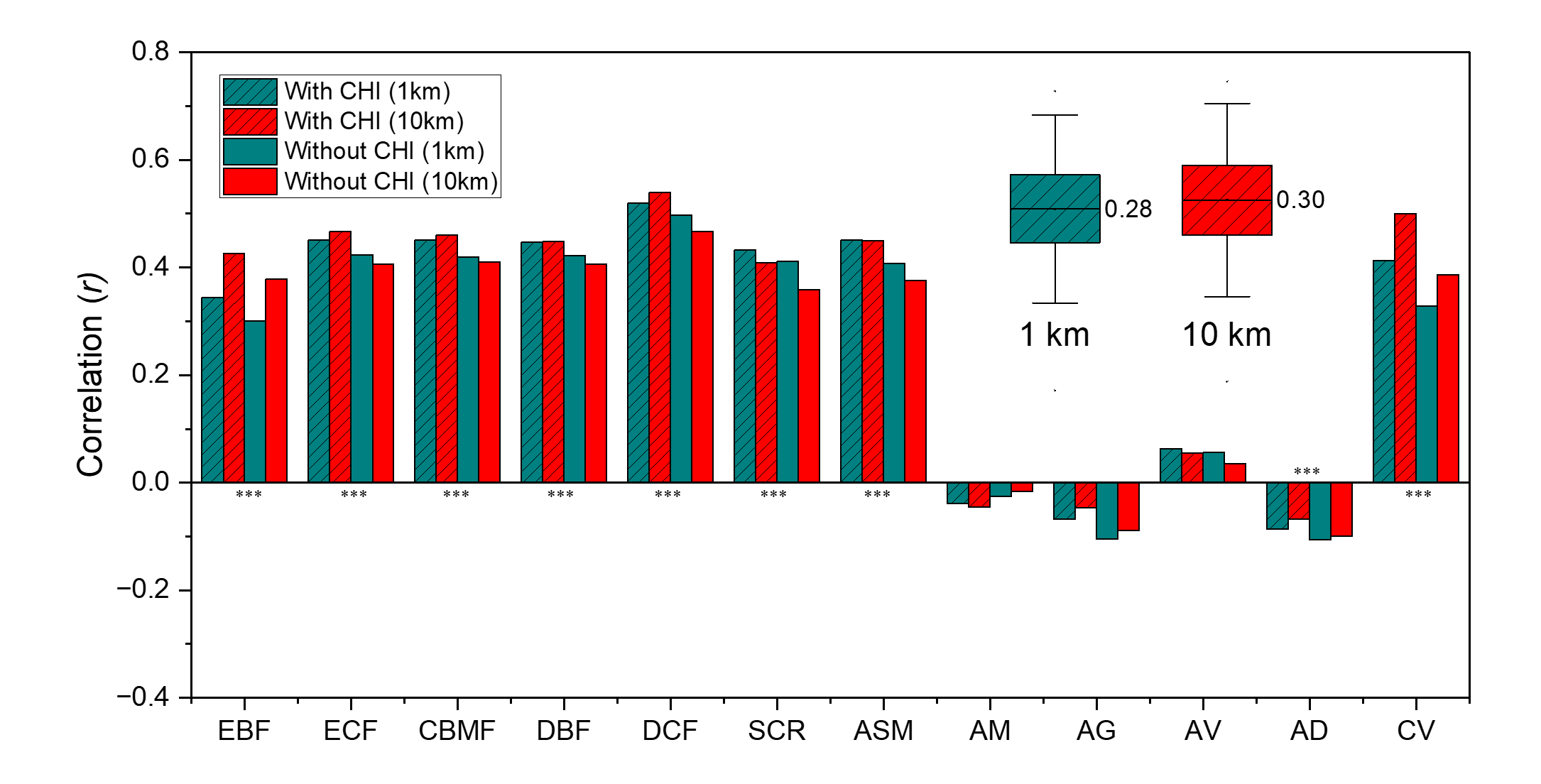
Fig. 1 Correlations between vegetation community complexity (VCC) and Suitability across vegetation types. Cyan and red represent the analyses at 1-km and 10-km resolutions, respectively. Bars indicate correlations for individual vegetation types, while boxplots summarize the overall correlations modelled with CHI.
The study further reveals a pronounced scale dependence of the CHI effect. At 10-km resolution. The potential change in vegetation suitability induced by incorporating the CHI is on average about 1.2 times that at 1-km resolution. This indicates that, as spatial resolution coarsens, fine-scale topographic signals such as valleys and slopes are progressively smoothed out, and the CHI can compensate for the environmental heterogeneity information missing from coarse-resolution data.
Further analyses show that at the 1-km scale, the model already captures topographic contrasts in elevation, slope and surface relief reasonably well, and vegetation suitability is largely controlled by fine-scale topography and the local climates it generates. At the 10-km scale, however, the influence of topographic detail weakens while that of regional climate becomes relatively stronger, so that the CHI plays a more pronounced compensatory role. The study thus mechanistically reveals a shift in vegetation modeling from topographic control at fine scales to climatic control at coarser scales.
In regions lacking high-resolution microclimate observations, the CHI can serve as an important bridge between macroclimate data and local climatic variation, enhancing the ecological realism of vegetation distribution models. The approach is expected to support the identification of protected areas, the prioritization of ecological restoration sites and the planning of climate-resilient ecological corridors, and to offer a methodological reference for biodiversity research in topographically complex regions such as the Andes and the Himalayas.
The study, entitled “Climate heterogeneity enhances macroclimate data-driven vegetation modeling on the Qinghai-Tibet Plateau,” has been published in Nature Communications. Associate Professor Guan Yanlong and master’s student Wu Wenqing of Fujian Agriculture and Forestry University are the co-first authors, while Chen Deliang of Tsinghua DESS, and Professor Zhou Shungui of Fujian Agriculture and Forestry University are the co-corresponding authors. The study was conducted in collaboration with Fujian Agriculture and Forestry University, Wuyi University, the Institute of Geographic Sciences and Natural Resources Research of the Chinese Academy of Sciences, Tsinghua University, the University of Helsinki and the Finnish Meteorological Institute. It was supported by the National Natural Science Foundation of China, the Natural Science Foundation of Fujian Province, the Carbon Neutrality and Energy System Transformation Program at Tsinghua University, and the Research Council of Finland.
Paper information:
Guan, Y., Wu, W., He, M., et al. Climate heterogeneity enhances macroclimate data-driven vegetation modeling on the Qinghai-Tibet Plateau. Nature Communications, 17, 7291 (2026). DOI:10.1038/s41467-026-73158-1
Full-text link:
https://www.nature.com/articles/s41467-026-73158-1
Contributed by Chen Deliang
Edited by Wang Jiayin
Reviewed by Yu Le



 Picture News
 Hot News