Africa and the Middle East, core regions of the global energy economy, also represent major sources of uncertainty in global carbon cycle research and climate modelling. Yet carbon dioxide emissions from oil and gas extraction and processing have long been underrepresented in official energy statistics and greenhouse gas inventories. Developing methods to independently, promptly, and accurately quantify carbon emissions in these regions is critical for guiding climate action.
To address these issues, the research team led by Professor Liu Zhu of the Department of Earth System Science (DESS) at Tsinghua University, together with researchers from the Netherlands Meteorological Institute, proposed a methodological framework for independently accounting for anthropogenic CO2 emissions in Africa and the Middle East based on satellite observations. The study established an independent satellite-based accounting and verification tool that does not rely on the spatial information or proxy data of traditional inventories, enabling effective tracking of emissions and filling of data gaps in regions where inventories are incomplete or lagging. With the upcoming launch of a new generation of satellites capable of simultaneously observing CO2 and NO2 (such as CO2M and TANGO), this method is expected to further improve the accuracy of emission factors and carbon emission estimates, laying a foundation for building an independent and transparent global carbon emission accounting system.
The study is based on NO2 observations from the TROPOMI satellite. The DECSO inversion algorithm was used to obtain the top-down total NOx emissions; after subtracting soil-source NOx emissions, the anthropogenic NOx emissions were obtained; combined with the CO2-to-NOx emission factor ratios from inventories, the satellite-constrained CO2 emissions were then derived. Taking 2019 as an example, the study covers three regions—Northern Hemispherical Africa, the Middle East, and Europe—at a spatial resolution of 0.2° × 0.2°. Unlike traditional inventories that rely on proxy data such as population, the geographic locations of emission sources, and land use for spatial allocation, the spatial distribution of emissions in this method is directly derived from satellite observations, which significantly reduces the spatial allocation uncertainty caused by proxy data and enables independent identification of emission sources that are missing or underestimated in inventories.

Figure 1 Spatial distribution of satellite-derived CO2 emissions in 2019 and their comparison with inventories
The study found that the satellite-derived CO2 emissions of the three regions—Northern Hemispherical Africa, the Middle East, and Europe—totaled 7.2 ± 0.6 Gt in 2019, while the inventories reported 6.3 ± 0.2 Gt, about 13% lower than the satellite estimates. By region, the satellite estimates differed from traditional inventories by 28%, 30%, and 15% for Africa, the Middle East, and Europe, respectively. Further analysis showed that about 35% of the underestimation came from the emission sources newly identified by the satellite, which exhibit clear signals in satellite observations but are nearly zero in traditional inventories. These newly identified emissions total about 332 Tg CO2, of which 98% are concentrated in Africa and the Middle East and are highly associated with oil and gas infrastructure.
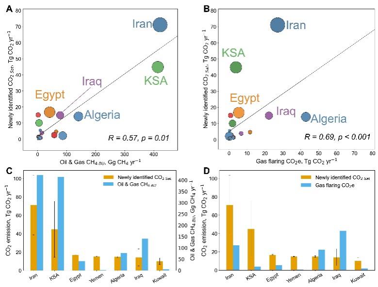
Figure 2 National-scale newly identified CO2 emissions and their correlation with oil and gas facilities
The study shows that traditional inventories also systematically underestimate known emission sources such as urban and industrial areas (by about 8.4%). At the national scale, the underestimation for Algeria, Iran, Egypt, and Iraq reaches 45%, 34%, 50%, and 51%, respectively. Through an analysis of the sectoral structure of the inventories, the study points out that the contribution of the transportation sector to the CO2 and NOx inventories is clearly inconsistent, which is one of the important causes of emission factor bias.
The related research results was published online on 31 July 2026 in the journal Science Advances under the title "Satellite observations reveal underestimation of CO2 emissions in Africa and the Middle East". Lin Xiaojuan, a postdoctoral researcher at the Laboratoire des Sciences du Climat et de l'Environnement (LSCE) and a doctoral graduate of the Department of Earth System Science at Tsinghua University, is the first author of the paper; Professor Liu Zhu of Tsinghua DESS and Researcher Ronald van der A of the Netherlands Meteorological Institute are the co-corresponding authors. The collaborators include Researcher Jos de Laat, Researcher Jieying Ding, and Researcher Henk Eskes of the Royal Netherlands Meteorological Institute. The research was supported by the National Key R&D Program of China, the National Natural Science Foundation of China, and the Carbon Neutrality and Energy Smart Interconnection international big science program, among other projects.
Full-text link: https://www.science.org/doi/10.1126/sciadv.aee1447
Written by Lin Xiaojuan and Liu Zhu
Edited by Wang Jiayin
Reviewed by Yu Le



 Picture News
 Hot News