Mountain precipitation, characterized by complex processes and marked spatial heterogeneity, has long been a key focus and challenge in hydrometeorology and global change research. Although satellite remote sensing, ground-based radar retrievals, and reanalysis precipitation products have been continuously improving, they still suffer from insufficient spatial resolution and considerable uncertainties in complex mountain regions. Ground-based precipitation observations with high representativeness, high density, and long time series remain extremely scarce. Consequently, how to scientifically and cost-effectively deploy precipitation observation stations in poorly accessible, topographically complex mountainous regions has been a persistent concern in international research.
To address the above problem, Academician Chen Deliang’s Research Group from the Department of Earth System Science (DESS), Tsinghua University, has conducted a systematic study and proposed a method for designing precipitation observation networks in mountain regions based on altitudinal precipitation gradient (APG) characteristics and land cover heterogeneity. The study first evaluates the applicability of multiple mainstream gridded precipitation products in mountainous areas and finds that the inter-product differences in mean annual precipitation are significantly higher in mountain regions than in non-mountainous areas, particularly over the Tibetan Plateau, the Tian Shan, and the Andes, indicating that mountains remain a weak link in global precipitation observation and product optimization.
Building on this, the study proposes from a meteorological and geographical perspective that station precipitation can be decomposed into four components: a horizontal zonal component (Ra), a vertical (altitudinal) zonal component (Rb), a non-zonal component (Rc), and an interactive effects component (Rd) (see equation in Figure 1). It further points out that, within a mesoscale basin with an area of approximately 2,000–20,000 km⟡, the multi-timescale characteristics of precipitation variation with elevation are key to understanding complex mountain precipitation processes. Based on this understanding, the team identifies mesoscale mountain basins (MMBUs) with pronounced APG characteristics at the global scale and classified them into six types using a parabolic precipitation-elevation regression model (Figure 1a–b, c–h). The results show that a total of 5024 MMBUs exhibit significant APG features, covering 63.9% of the global mountain areas.
Based on the above findings, the study further proposes a hierarchical station deployment strategy using mesoscale basins as basic units: first, deploy baseline stations along the altitudinal gradient to characterize the overall precipitation pattern of the basin; then, add densified observations in areas with non-zonal land cover types to capture local precipitation differences. This strategy can be summarized as "using mesoscale basins as units, deploying stations hierarchically, and prioritizing the basin-wide pattern before local details." The study estimates that implementing this scheme across the 5,024 target mountain basins worldwide would require approximately 64,000 gauges (Figure 1i), which would largely meet the ground observation needs for mesoscale mountain precipitation processes, with a total construction cost that is practically feasible. This research provides a new approach to improving the spatiotemporal representativeness and cost-effectiveness of mountain precipitation observations, and offers scientific support for optimizing mountain hydrometeorological observation systems.
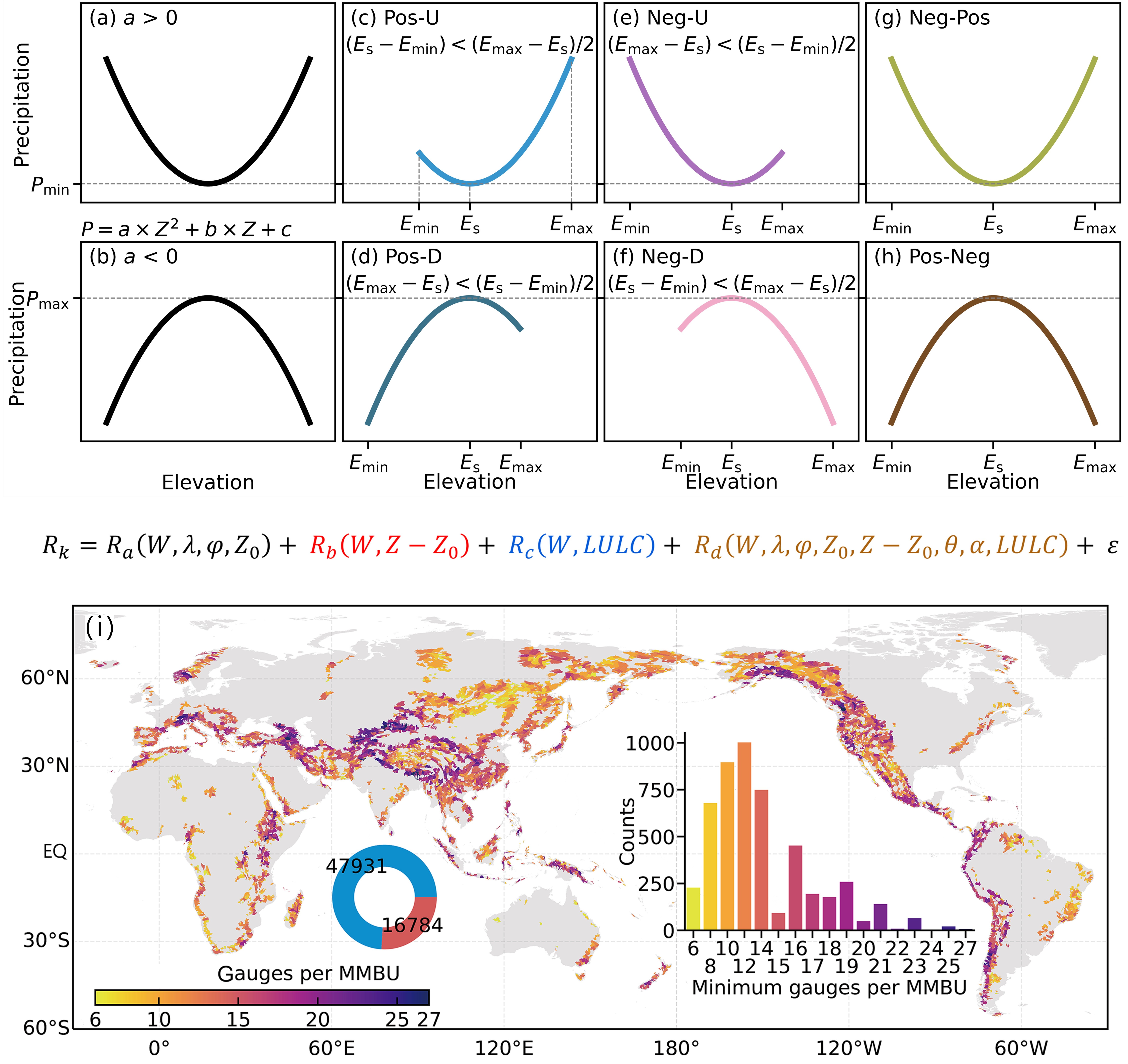
Figure 1. Scientific design scheme for global mountain precipitation observation networks. (a–h) Classification method of altitudinal precipitation gradients in mesoscale mountain basins. (a–b) General form of parabolic fitting; (c–d) two positive correlation types; (e–f) two negative correlation types; (g–h) two mixed types. (Equation) Conceptual model of precipitation amount for a single precipitation event at a station. (i) Recommended minimum number of precipitation observation gauges per mesoscale mountain basin unit (MMBU).
The relevant findings, titled "Designing precipitation networks from altitudinal gradient patterns in global mountain basins," were published in the English edition of Advances in Climate Change Research and were selected as the cover article of the issue. Dr. Liu Rui-Shun, a postdoctoral fellow from the Department of Earth System Science (DESS), Tsinghua University, is the first author, and Academician Chen Deliang is the corresponding author, with Professor Wang Lei from the Institute of Tibetan Plateau Research, Chinese Academy of Sciences, as co-corresponding author. Co-authors include Professor Yang Kun from Tsinghua DESS, Associate Professor Gao Shan and Academician Yao Tan-Dong from the Institute of Tibetan Plateau Research, Chinese Academy of Sciences. The research was supported by the National Key R&D Program of China, the Second Tibetan Plateau Scientific Expedition and Research Program (STEP), and relevant projects of Tsinghua University.
Full-text link:
https://doi.org/10.1016/j.accre.2026.02.007
Written by Liu Rui-Shun and Chen Deliang
Edited by Wang Jiayin
Reviewed by Zhang Qiang


 Picture News
 Hot News

