Aerosol-cloud interactions (ACI) are considered to potentially offset the radiative forcing of greenhouse gas-induced warming in the Earth-atmosphere system. The increase in anthropogenic aerosols affects the size distribution of cloud droplets (cloud droplet spectrum) in water clouds, leading to changes in cloud radiative forcing. This process, known as the dispersion effect (DE), is a critical component of ACI. However, due to the lack of global quantitative methods based on satellite observations, current studies estimating the climate effects of aerosols often neglect DE, resulting in significant systematic biases. Additionally, parameterization schemes for cloud droplet spectra in current climate models are primarily based on regional aircraft observations, lacking quantitative validation against global-scale observational data, which limits the development and improvement of these schemes.
To address this problem, Associate Professor Peng Yiran’s Research Group from the Department of Earth System Science (DESS) at Tsinghua University, in collaboration with Researcher Husi Letu’s team from the Aerospace Information Research Institute of the Chinese Academy of Sciences, proposed a novel method based on the mechanisms of cloud microphysical processes and theoretical derivations of relevant equations. By combining observations from the multi-angle polarimetric satellite POLDER, they achieved the first global quantitative assessment of DE’s impact on ACI in liquid-phase stratiform clouds. The results show that DE offsets the ACI induced by changes in cloud droplet number concentration and liquid water path adjustments by 7% and -1.4%, respectively, partially mitigating the cooling effect of aerosols on global warming.
Building on this, the research team also developed a new parameterization scheme based on a global satellite dataset of cloud droplet spectral parameters. This scheme is expected to improve the simulation capability of climate models for cloud droplet spectra and DE in liquid-phase stratiform clouds. The quantitative methods and parameterization schemes proposed in this study not only deepen the scientific understanding of DE but also provide globally representative computational methods and evaluation data for cloud droplet spectra in climate models. This advancement is significant for improving the accuracy of ACI estimates and reducing uncertainties in simulating aerosol climate effects.
The study first combined the newly proposed quantitative method with POLDER satellite observations to calculate the global distribution of cloud droplet spectral parameters and determined the offset rates of DE on different ACI (Figure 1). The results reveal significant spatial variability in spectral parameters and the impact of DE: in regions heavily influenced by human activities, spectral parameters are larger (indicating broader cloud droplet spectra), reflecting the broadening effect of aerosols on cloud droplet spectra, which partially offsets the cooling effect of ACI.
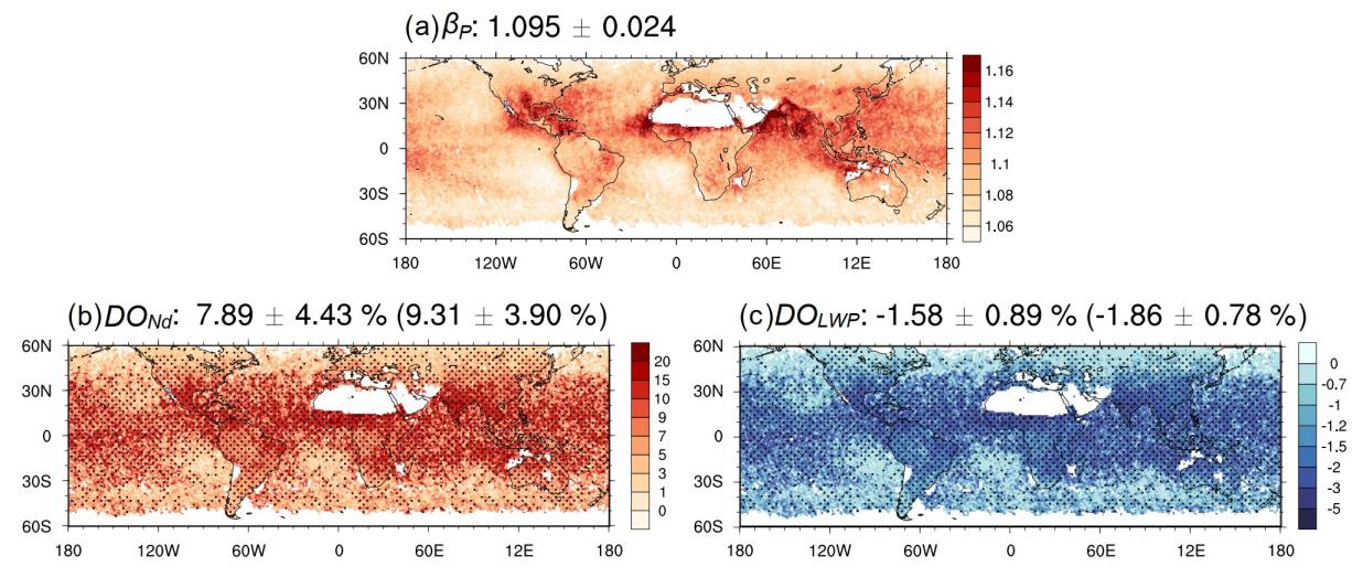
Figure 1. Spatial distribution of cloud droplet spectral parameters and DE impact.
Using the global dataset of cloud droplet spectral parameters derived from satellite observations, the study proposed a new parameterization scheme. Compared to traditional schemes, this scheme does not rely on observations from specific regions, and offered greater global representativeness and better alignment with the needs of climate models. Additionally, considering differences in aerosol impact mechanisms over land and ocean, the study provided separate parameterization schemes for these surfaces, allowing flexible application in models based on simulation requirements (Figure 2).
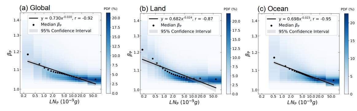
Figure 2. Spectral parameterization schemes based on global, land, and ocean data.
To ensure the reliability of the results, the study conducted a comprehensive uncertainty analysis of key parameters in DE calculations, accounting for errors in satellite observation datasets, the influence of cloud inhomogeneity, the impact of wavelength and grid scale in satellite retrieval methods, and the effects of fitting methods on quantitative results. Optimal estimates and 90% uncertainty ranges were provided (Figure 3).
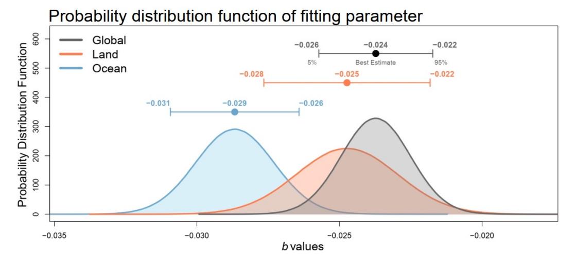
Figure 3. Probability density distributions of key parameters for calculating DE globally and over land and ocean.
These findings were recently published in Nature Communications under the title "Global Quantification of the Dispersion Effect with POLDER Satellite Data."
Wang Hengqi, a Class 2019 Ph.D. graduate from Tsinghua DESS (now an assistant researcher at the Aerospace Information Research Institute of the Chinese Academy of Sciences), is the first author of the paper, with Associate Professor Peng Yiran serving as the corresponding author. Collaborators include Professor Johannes Quaas from the University of Leipzig, Germany; Researcher Husi Letu and Associate Researcher Shang Huazhe from the Aerospace Information Research Institute of the Chinese Academy of Sciences; Assistant Professor Antonio Di Noia from the University of Bremen, Germany; Researchers Bastiaan van Diedenhoven and Otto P. Hasekamp from the Netherlands Institute for Space Research; and Researcher Liu Yangang from Brookhaven National Laboratory, USA. The research was supported by the National Natural Science Foundation of China (42175096 and 42025504), the Hebei Key Research and Development Program (20375402D), the National Key Research and Development Program of China (2023YFB3905900), the National Major Science and Technology Infrastructure Project "Earth System Numerical Simulation Facility," and the China Scholarship Council.
Full-text link: https://doi.org/10.1038/s41467-025-62238-3
Citation: Wang, H., Peng, Y., Di Noia, A. et al. Global quantification of the dispersion effect with POLDER satellite data. Nat Commun 16, 7087 (2025). https://doi.org/10.1038/s41467-025-62238-3
Written by Hengqi Wang and Peng Yiran
Edited by Wang Jiayin
Reviewed by Geng Rui


 Picture News
 Hot News

