Under the dual pressures of climate change and urbanization, urban thermal environments face severe challenges. Trees, as a core element of Nature-based Solutions (NBS), have attracted significant attention for their notable cooling effects. However, current research on the relationship between tree cooling effects and tree height, especially at large scales, remains insufficient, and the underlying mechanisms have not been fully quantified or explored. This gap not only limits the formulation of optimization recommendations for urban thermal environments but also hinders the further development of mesoscale urban climate models.
To address this challenge, Professor Xu Bing's Research Group from the Department of Earth System Science (DESS) at Tsinghua University conducted a study across 305 cities in China. Utilizing high-resolution remote sensing data and multi-source geographic big data, combined with various statistical models and urban hydrological models, the team quantified the impact of tree height on land surface temperature (LST) and its underlying mechanisms (Figure 1).
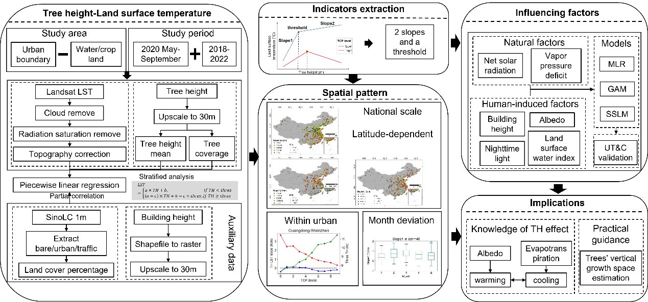
Figure 1: Research Workflow
The results show that the impact of tree height on LST is comparable in magnitude to that of tree coverage, exhibiting a piecewise linear relationship. After controlling for tree coverage, LST initially increases and then decreases with increasing tree height (Figure 2). In areas with low tree coverage, tree height promotes an increase in LST, whereas in areas with high tree coverage, increasing tree height significantly reduces LST.
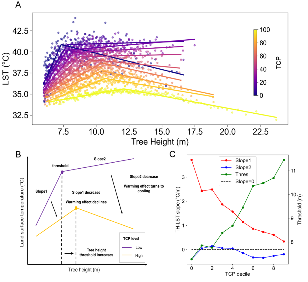
Figure 2 (A) The piecewise linear relationship between tree height and LST in Shenzhen, China, with scatter points of different colors representing varying tree coverage percentages (TCP). (B) Extraction of two linear slopes (slope1, slope2) and the threshold tree height at the inflection point based on the fitted relationship. (C) Line plots showing changes in the three parameters with TCP.
The impact of tree height on LST exhibits distinct spatial heterogeneity. Based on a city-level piecewise linear fitting model (extracting two slopes and the threshold tree height: slope1, slope2, and threshold), the cooling effect of tree height (slope2) and the threshold tree height display a latitudinal distribution pattern segmented at 30°N and 40°N (Figure 3). This spatial pattern is attributed to differences in built environments or dominant tree species among urban clusters at different latitudes.
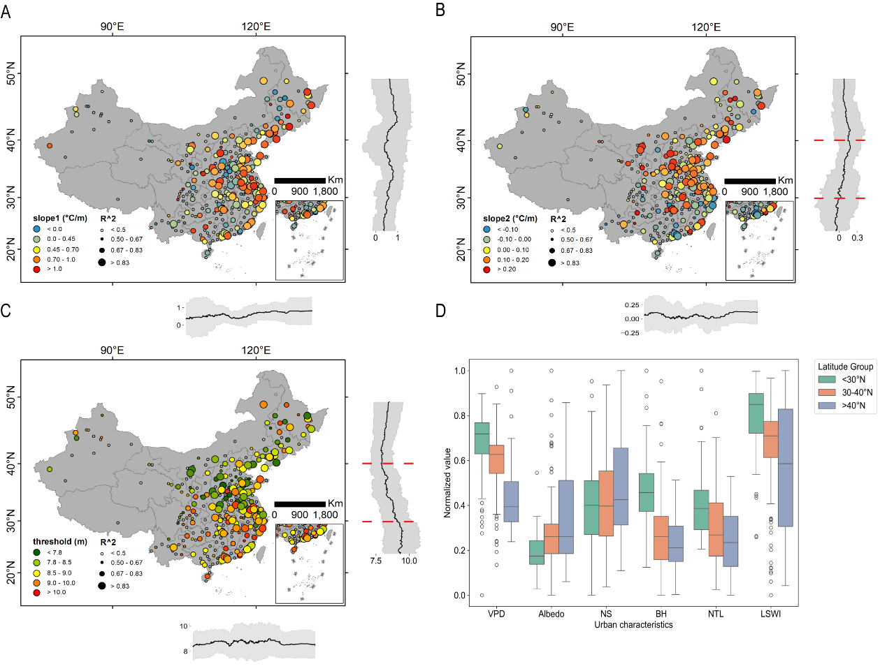
Figure 3 Spatial distribution of the impact of tree height on LST.
(A) slope1, (B) slope2, and (C) the spatial distribution of the threshold tree height.
(D) Urban clusters divided by 30°N and 40°N, showing differences in built environments, including vapor pressure deficit, albedo, net solar radiation, building height, nighttime light, and surface water content.
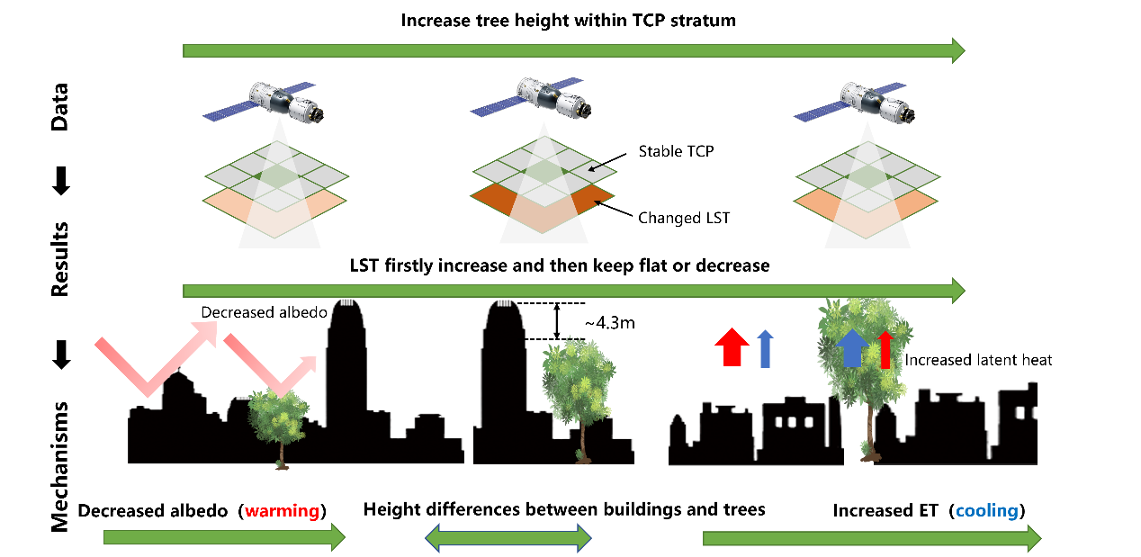
Correlation analysis revealed that slope1 is nonlinearly influenced by urban albedo, slope2 shows a significant negative correlation with vapor pressure deficit, and the threshold tree height is significantly positively correlated with building height. Simulations from urban hydrological models summarized the nonlinear mechanism of tree height's impact on LST: (1) Increasing tree height reduces local albedo, causing urban canyons to absorb more radiant energy and raising LST (warming effect). (2) Increasing tree height enhances evapotranspiration rates, reducing sensible heat flux and lowering LST (cooling effect).
When the increase in evapotranspiration offsets the decrease in albedo, tree height produces a cooling effect. This threshold depends on the height difference between trees and surrounding buildings. The results indicate that, on average, Chinese urban trees need to be no more than 4.3 meters shorter than buildings to achieve a cooling effect. Specifically, 31% of cities have a tree-building height difference of less than 3 meters (one-story height), and 73% have a difference of less than 6 meters (two-story height).
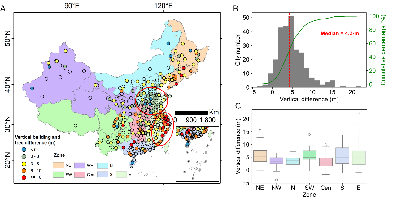
Figure 4 The height contrast between buildings and trees corresponding to the threshold in Chinese cities.
This study quantifies the nonlinear impact of tree height on urban temperature at a national scale, revealing the regulatory role of the interaction between buildings and trees on urban thermal environments. The findings provide actionable recommendations for urban planning in an era of increasing extreme heat, enhancing the scientific understanding of trees' impact on urban climates.
The research findings, titled "Vertical contrast of trees and buildings determines urban land surface temperature," were published in Landscape and Urban Planning, with Wei Hong (Ph.D. candidate, Tsinghua University) as the first author, Professor Xu Bing (Tsinghua University) as the corresponding author, and co-authors including Associate Professor Chen Bin (University of Hong Kong), Research Assistant Professor Wu Shengbiao (University of Hong Kong), Associate Professor Yin Yi (New York University), and Dr. Zhang Tao (Tsinghua University). This study was supported by the National Natural Science Foundation of China (Grant No. 42090015).
Full-text link:
https://www.sciencedirect.com/science/article/pii/S0169204625001550
Written by Wei Hong
Edited by Wang Jiayin
Reviewed by Geng Rui

 Picture News
 Hot News

