Recently, the China Meteorological Forcing Data (CMFD) Version 2.0, jointly developed by the Institute of Tibetan Plateau Research, Chinese Academy of Sciences, and the Department of Earth System Science (DESS), Tsinghua University, has been publicly released. Users can download the data from the National Tibetan Plateau Data Center. CMFD is a set of high-precision, high-resolution, and long-time-series data products developed to support research in land surface, hydrology, ecology, and other fields in China. CMFD 2.0 recently released includes meteorological elements such as near-surface air temperature, air pressure, specific humidity, total wind speed, downward shortwave radiation flux, downward longwave radiation flux, and precipitation rate. It has a temporal resolution of 3 hours, a horizontal spatial resolution of 0.1°, and a time span of 74 years (1951–2024), covering the land area within the spatial range of 70°E–140°E and 15°N–55°N (Fig. 1).
CMFD 2.0 integrates the ERA5 reanalysis data from the European Centre for Medium-Range Weather Forecasts (ECMWF) and meteorological station observation data. It also incorporates the ISCCP-ITP-CNN and TPHiPr data products produced using artificial intelligence technology in radiation and precipitation data products (Fig. 2), with significantly improved data accuracy compared to the previous version of CMFD.
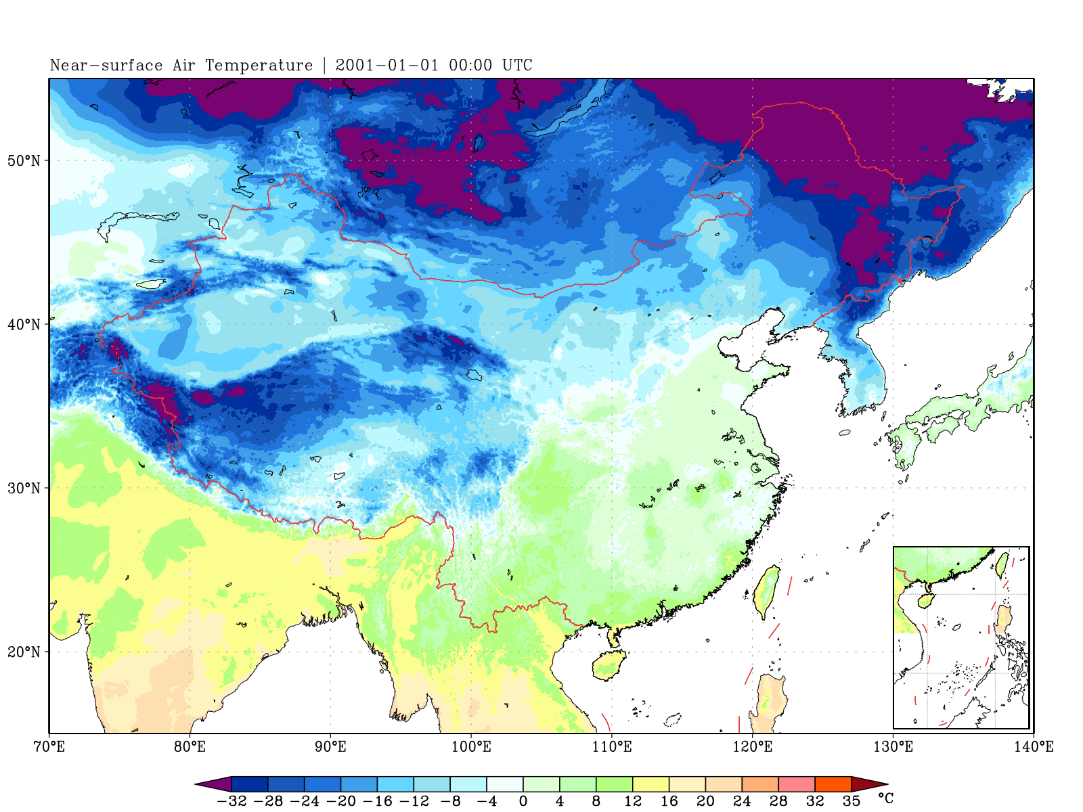
Fig. 1 The near-surface air temperature distribution at 00:00 UTC on January 1, 2001, drawn based on CMFD 2.0 data. It can be seen that CMFD 2.0 clearly presents the law of near-surface air temperature changing with terrain elevation, with rich details in the spatial distribution of variables, and the effective data spatial range has been expanded to the land areas surrounding China.
The CMFD 1.6 released by the research team in 2019 has been widely cited, supporting the publication of over 1,000 papers and becoming one of the most influential data in the National Tibetan Plateau Science Data Center. CMFD V1.6 employed conventional data fusion techniques, whereas the newly released V2.0 leverages AI-enhanced optimization to achieve significant upgrades in several aspects. Beyond integrating AI-generated radiation and precipitation data, the CMFD V2.0 development team prioritized single-sourced reanalysis inputs and incorporated meteorological station relocation records. This approach effectively mitigates spurious climate discontinuities—prevalent in CMFD V1.6 due to multi-source data splicing and unaccounted station relocations (Fig. 3). At the same time, the data time span of CMFD 2.0 has been expanded from 40 years in CMFD 1.6 to 74 years. The grid spatial range of CMFD 2.0 is the same as that of CMFD 1.6, but its effective data has been expanded beyond China (Fig. 1), which can better support cross-border regional research.
To streamline data accessibility, CMFD 2.0 supplements core variables with derived products—including near-surface relative humidity and precipitation phase-partitioned datasets. Crucially, CMFD 2.0 implements native floating-point compression within NetCDF4 format, abandoning the integer conversion via scale_factor/add_offset parameters used in CMFD 1.6. This architectural upgrade eliminates decompression calculations during data utilization.
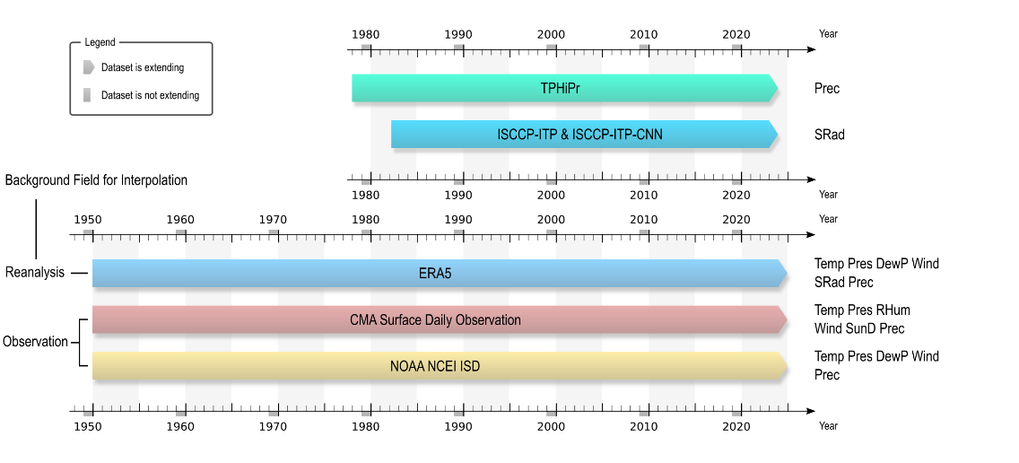
Fig. 2 The data used to make CMFD 2.0 and their time lengths, where the three sets of data below are the input data used for site-reanalysis data blending, and the two sets of data in the upper right are the radiation and precipitation data products directly integrated into CMFD 2.0.
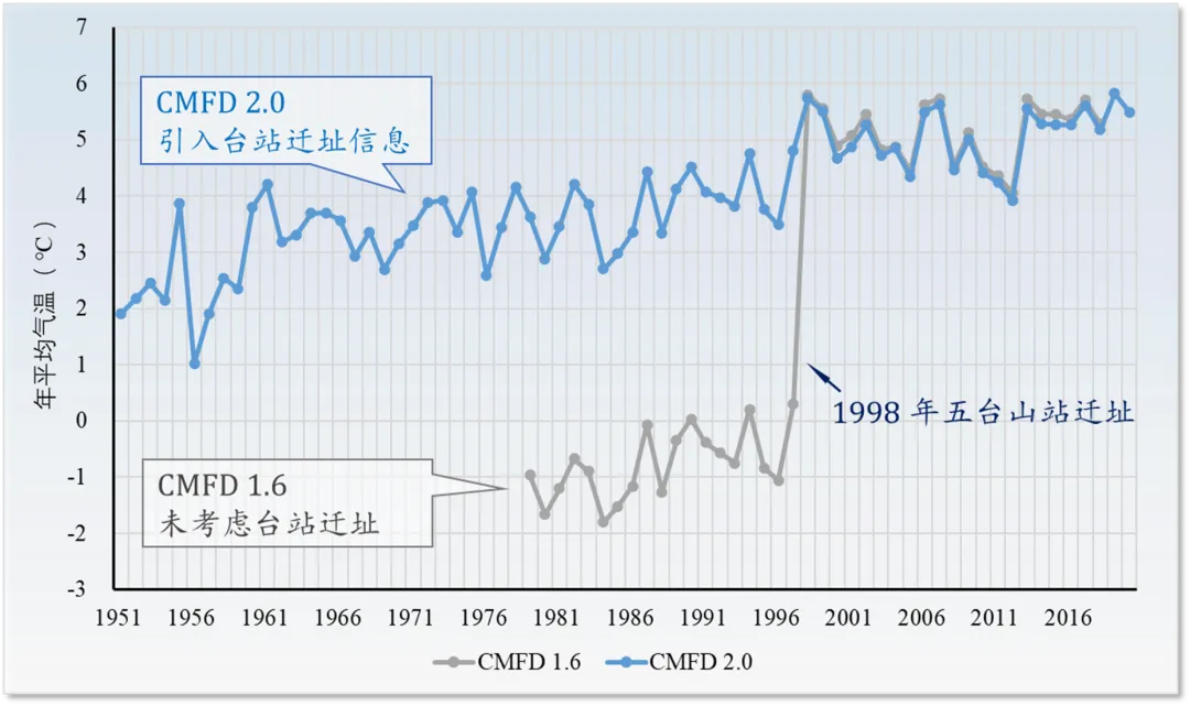
Fig. 3 The comparison of the annual mean temperature time series of the grid near Wutai Mountain Station (113.55°E, 38.95°N) before and after CMFD considered the relocation information of the station. It can be seen that CMFD 2.0 has corrected the f spurious climate discontinuities caused by the relocation of Wutai Mountain Meteorological Station.
CMFD 2.0 was jointly led by the Data Department of the National Tibetan Plateau Science Data Center, Institute of Tibetan Plateau Research, Chinese Academy of Sciences, and Professor Kun Yang’s team from the DESS, Tsinghua University. Dr. He Jie, Professor Yang Kun, and Researcher Li Xin were fully responsible for the planning, algorithm formulation, data production, and release of CMFD 2.0. Researcher Tang Wenjun and PhD candidate Shao Changkun developed the downward shortwave radiation flux data ISCCP-ITP-CNN, Dr. Jiang Yaozhi developed the Tibetan Plateau precipitation data TPHiPr, and Dr. Ding Baohong developed the precipitation phase partitioning algorithm for CMFD 2.0. In addition to the core data research and development team, the development of CMFD 2.0 has also been strongly supported by many domestic research institutions and scholars. Researcher Maimaitiaili Maimaitiyiming from the Urumqi Desert Meteorological Institute, China Meteorological Administration, Senior Engineer Zhou Bingrong and Senior Engineer Quan Chen from the Qinghai Institute of Meteorological Science, Associate Researcher Kong Xianghui from the Institute of Atmospheric Physics, Chinese Academy of Sciences, Associate Researcher Ma Tingting from the China Meteorological Administration Training Center, and Senior Engineer Wu Shenggang from the Chongqing Meteorological Observatory all provided help for the development of CMFD 2.0, and the Service Department of the National Tibetan Plateau Data Center provided all-round support for data release.
Article Information:
1. He, J., Yang, K., Tang, W. Lu, H., Qin, J., Chen, Y.Y., & Li, X. (2020). The first high-resolution meteorological forcing dataset for land process studies over China. Scientific Data, 7, 25,https://doi.org/10.1038/s41597-020-0369-y.
2. Tang, W., Yang, K., Qin, J., Li, X., & Niu, X. (2019). A 16-year dataset (2000–2015) of high-resolution (3 h, 10 km) global surface solar radiation. Earth Syst. Sci. Data, 11, 1905–1915, https://doi.org/10.5194/essd-11-1905-2019.
3. Jiang, Y., Yang, K., Qi, Y., Zhou, X., He, J., Lu, H., Li, X., Chen, Y., Li, X.D., Zhou, B., Mamtimin, A., Shao, C., Ma, X., Tian, J., & Zhou, J. (2023). TPHiPr: a long-term (1979–2020) high-accuracy precipitation dataset (1/30◦, daily) for the Third Pole region based on high-resolution atmospheric modeling and dense observations. Earth Syst. Sci. Data 15, 621–638.https://doi.org/10.5194/essd-15-621-2023.
4. Shao, C., Yang, K., Tang, W., He, Y., Jiang, Y., Lu, H., Fu, H., & Zheng, J. (2022). Convolutional neural network-based homogenization for constructing a long-term global surface solar radiation dataset. Renewable and Sustainable Energy Reviews, 169(September), 112952. DOI:10.1016/j.rser.2022.112952.
Data information:
He, J., Yang, K., Li, X., Tang, W., Shao, C., Jiang, Y., Ding, B. (2024). China meteorological forcing dataset v2.0 (1951-2024). National Tibetan Plateau / Third Pole Environment Data Center.https://doi.org/10.11888/Atmos.tpdc.302088.https://cstr.cn/18406.11.Atmos.tpdc.302088.


 Picture News
 Hot News

