According to UN-Habitat, at present 1 billion people worldwide live in slums or informal settlements, which number is expected to hit 3 billion in the future three decades. The problems for slums such as poverty, natural disasters, hygiene, health and diseases have become key issues of concern for the global sustainable development goals.
Due to the lack of basic information concerning the spatial distribution of slums, relevant research is still at the preliminary stage, preventing the effective implementation of the measures for sustainable development goals. Regarding this problem, A/Prof. Yu Le’s Research Group of DESS, Tsinghua University has chosen Nigeria, Ghana, Kenya, and Malawi as study cases. Through a comprehensive sample survey of slums in these countries, social survey data (Demographic and Health Surveys, DHS), remote sensing data and other geospatial data have been integrated, urban morphological indicators and socio-economic indicators have been extracted, and the spatial distribution of slums has been monitored by unsupervised classification and tree-based clustering framework.

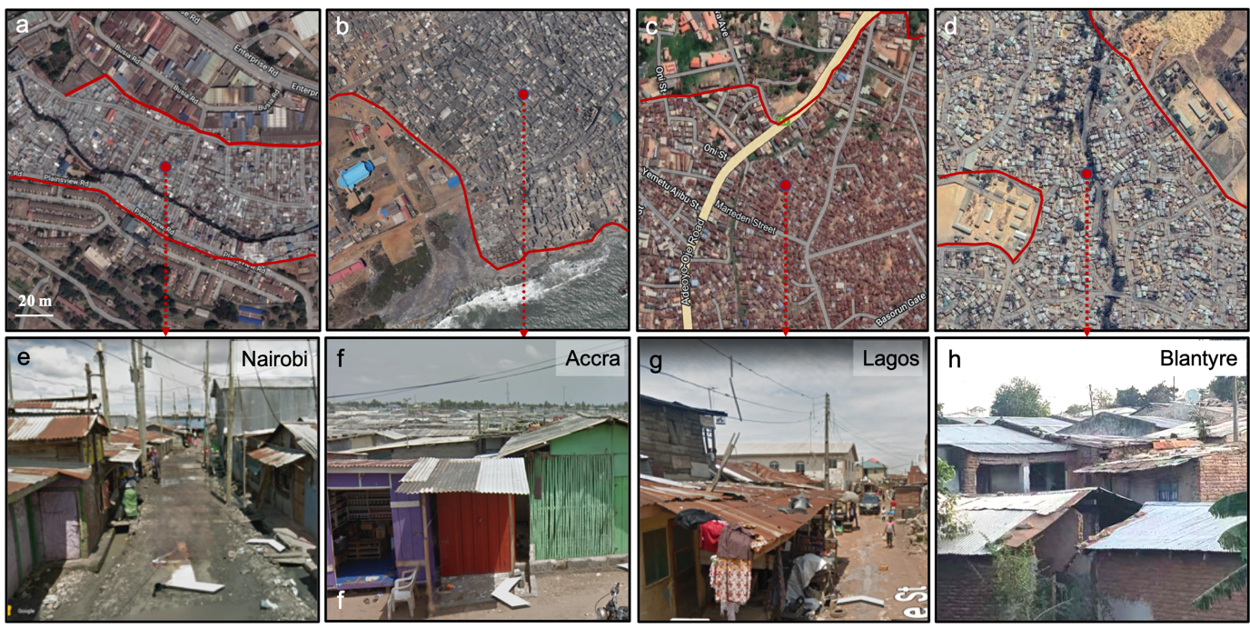
Fig. 1. Showcases of Google Earth images (a-d) and Google Street View photos (e-g) and field photo (h) illustrating slum areas in Nairobi, Kenya (a, e), Accra, Ghana (b, f), Lagos, Nigeria (c, g), Blantyre, Malawi (d, h).
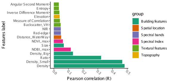
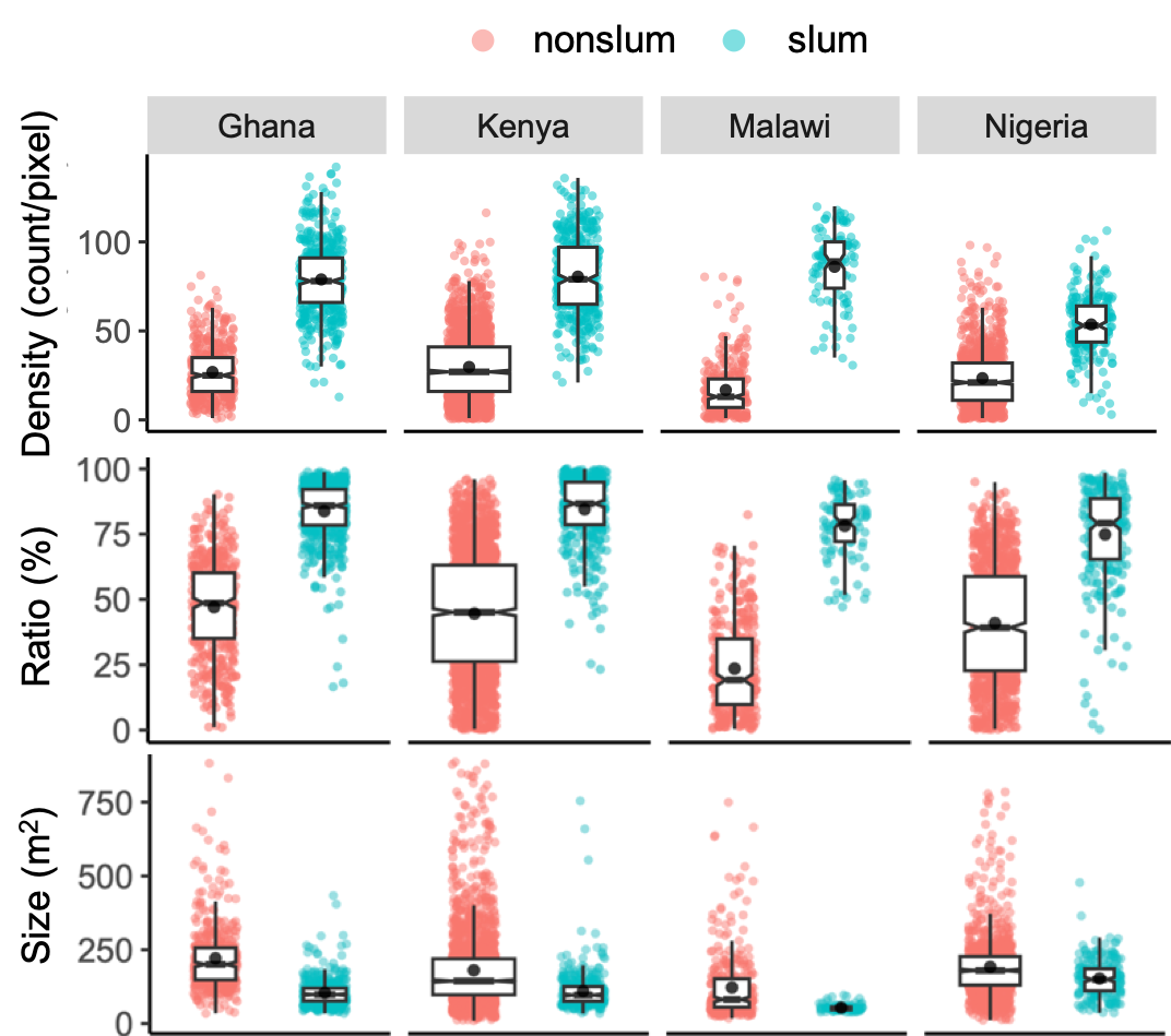
It has been found in the study that urban morphological features (such as housing density, ratio and size) are important factors for automatically extracting slums (Fig. 2). Compared with other urban areas, the housing density and ratio in slums are higher, while the housing size is smaller (Fig. 3). Our findings indicate that morphological clusters with compact, small buildings are indicative of a high prevalence of slums, with an accuracy rate of 83.6%. These areas are defined as morphological slums. These morphological slum clusters exhibit significant correlations with socio-economic indicators, exhibiting lower GDP and wealth index and inadequate infrastructure compared to neighbouring clusters.

Fig. 2. Pearson correlation between slum occurrence (slum:1, non-slum:0) and selected physical features

Fig. 3. Building feature differences (in density, ratio and size) between slum and non-slum groups.
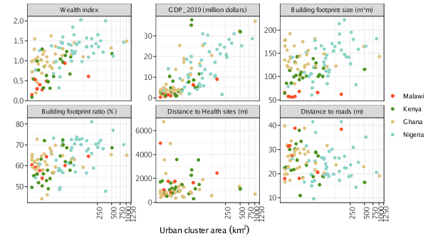
Besides, by comparing the features of morphological slums in 95 cities in 4 countries, it is found that the slums with larger scale and longer construction time have better economic development and relatively perfect infrastructure (Fig. 4). The research provides a methodological basis for identifying the location of slums on a global scale and revealing their distribution patterns.

Fig. 4. Scatterplot of socio-economic variables and morphological features of slum clusters in cities with different size.
The related results have been published in Sustainable Cities and Society as a paper titled “Slum and urban deprivation in compacted and peri-urban neighborhoods in sub-Saharan Africa”. Li Chengxiu, a postdoctoral fellow of the DESS is the first author, and A/Prof. Yu Le is the corresponding author. Collaborating units include Institute of Geographic Sciences and Natural Resources, Chinese Academy of Sciences, University of Hong Kong, Technical University of Kenya, University of Malawi, Malawi University of Science and Technology, University of Southampton, Michigan State University, the African Institute for Mathematical Sciences and University of Exeter. This work was funded through National Key R&D Program of China, China Postdoctoral Science Foundation, and Tsinghua University Initiative Scientific Research Program.
Full-text link of the paper: https://doi.org/10.1016/j.scs.2023.104863
Written by Li Chengxiu and Yu Le
Edited by Wang Jiayin
Reviewed by Zhang Qiang