The National Tibetan Plateau Data Center, as a research paper relational database, has recently published “A global daily soil moisture dataset derived from Chinese FengYun-3B Microwave Radiation Imager (MWRI) (2010–2019) (https://doi.org/10.11888/Terre.tpdc.271954) co-developed by Associate Professor Lu Hui’s team of the Department of Earth System Science (DESS), Tsinghua University and Researcher Shi Jiancheng’s team of the National Space Science Center, Chinese Academy of Sciences. The data is open for free access. The related article titled “A global daily soil moisture dataset derived from Chinese FengYun-3B Microwave Radiation Imager (MWRI) (2010-2019)” (https://www.nature.com/articles/s41597-023-02007-3 ) has been published in Scientific Data.
Surface soil moisture (SSM) is an important basis for research in drought monitoring, floods predicting, weather forecasting, etc. Currently, SSM products from L-band observations, such as the Soil Moisture Active Passive (SMAP) Mission of NASA , have proven to be optimal global estimations. Chinese FengYun-3 series satellites (FY-3A/B/C/D) have provided sustainable and daily multiple SSM products from X-band since 2008. However, X-band has a lower sensitivity to soil moisture than that of L-band, and the accuracy of FY-3 soil moisture products is to be improved.
This research developed a new global SSM product (NNsm-FY) from FY-3B MWRI from 2010 to 2019, and transferred high accuracy of SMAP L-band to FY-3B X-band. The NNsm-FY shows good agreement with in-situ observations and SMAP product and has a higher accuracy than that of official FY-3B product. With this new dataset, Chinese FY-3 satellites may play a larger role and provide opportunities of sustainable and longer-term soil moisture data record for hydrological study.
Associate Professor Lu Hui’s team of the Department of Earth System Science (DESS), Tsinghua University, in conjunction with Researcher Shi Jiancheng’s team of the National Space Science Center, Chinese Academy of Sciences, and using the microwave radiation transmission model and machine learning method, has transferred the high accuracy of SMAP satellite L-band to FY satellite X-band, to develop a FY-3B global daily soil moisture dataset (2010-2019), with a spatial resolution of 36 km and a data unit of m3/m3. Verified by 14 intensive ground verification networks and 258 sites around the world, the dataset matches well with ground observation and SMAP products, and its accuracy is higher than that of FY satellite official soil moisture products (Fig. 2).
The research team has also released the AMSR-E/AMSR2 soil moisture products (https://doi.org/10.11888/Soil.tpdc.270960) in the recent two decades, drawing extensive attention and being widely applied because of their accuracy comparable to SMAP and longer time series. This FY dataset is highly consistent with AMSR-E/AMSR2, and therefore it can fill the data gap of AMSR series from October 2011 to June 2012 (Fig. 2).
Through the production and release of this dataset and subsequent series of data, China FY-3 series satellites can provide sustainable and long-time soil moisture dataset products to promote Chinese satellites to play a greater role in hydrological research and other fields.
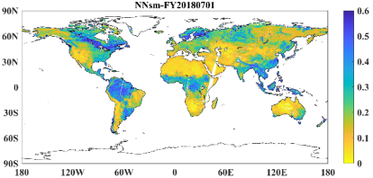
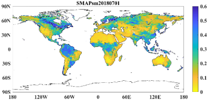
(a) This dataset NNsm-FY (b)SMAP official product SMAPsm
Fig. 1 Distribution maps of soil moisture on July 1 (3 day synthesis)
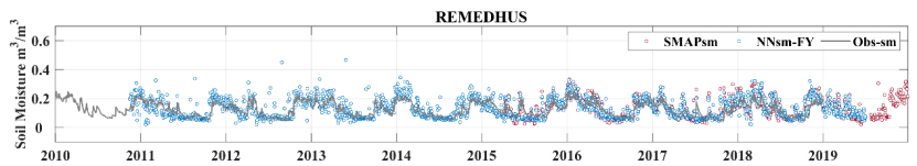
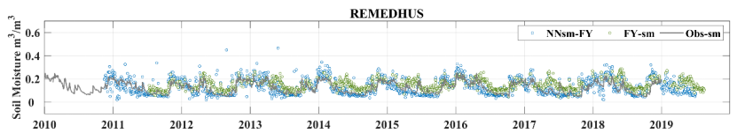
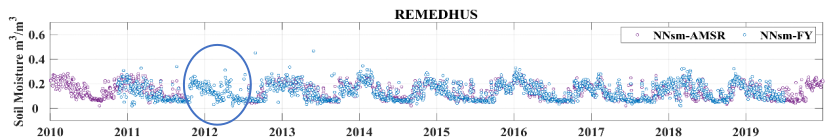
Fig. 2 Time series comparison over in situ networks: Obs-sm (grey dots), SMAPsm (red dots), and NNsm-FY (blue dots), FY-sm (green dots), and NNsm-AMSR (purple dots).
This research and development of this dataset has been supported by a Major Project of the National Natural Science Foundation of China, “Spatio-temporal Multi-scale Intelligent Remote Sensing of Key Parameters of Land Water Cycle” (grant no. 42090014), the Second Tibetan Plateau Scientific Expedition and Research Program (STEP) (grant no. 2019QZKK0206), and the National Key Research and Development Program of China (grant no. 2018YFB0504905).
Paper information:
1. Yao, P.P., Lu, H., Zhao, T.J., Wu, S.L., Peng Z.Q., Cosh, M.H., Jia L., Yang K., Zhang, P., Shi, J.C. A global daily soil moisture dataset derived from Chinese FengYun-3B Microwave Radiation Imager (MWRI) (2010-2019). Scientific Data. 2023. https://www.nature.com/articles/s41597-023-02007-3.
Data information:
1. Shi Panpan, Lu Hui, Zhao Tianjie, Wu Shengli and Shi Jiancheng (2021). A global daily soil moisture dataset derived from Chinese FengYun-3B Microwave Radiation Imager (MWRI) (2010-2019). National Tibetan Plateau Data Center, https://doi.org/10.11888/Terre.tpdc.271954. https://cstr.cn/18406.11.Terre.tpdc.271954.
2. Yao Panpan and Lu Hui (2020). A long term global daily soil moisture dataset derived from AMSR-E and AMSR2 (2002-2022). National Tibetan Plateau Data Center, https://doi.org/10.11888/Soil.tpdc.270960. https://cstr.cn/18406.11.Soil.tpdc.270960.
Written by Yao Panpan


 Picture News
 Hot News

