With the rise of global temperature, extreme weather events have increased, leading to changes in water cycle characteristics (such as river runoff and seasonal peak), which can more easily trigger the occurrence of droughts and floods. The latest Coupled Model Intercomparison Project Phase 6 (CMIP6) proposes new shared pathways (SSPs) that incorporate socioeconomic development with more comprehensive and scientific experimental designs. However, the observation data of Chinese stations referred to in the existing data of CMIP6 model are limited, which leads to the bias in its hydrological application in China. It is therefore still necessary to conduct a comprehensive study of the future hydrological changes in China by combining more station observation data and a higher-precision high-resolution global climate model.
With regard to the above problems, Associate Professor Lu Hui’s Research Group of the Department of Earth System Science (DESS), Tsinghua University uses the Equidistant Cumulative Distribution Function method (EDCDFm) to perform downscaling and bias correction in daily precipitation, daily maximum temperature, and daily minimum temperature for six CMIP6 models (CanESM5, FGOALS-g3, GFDL-CM4, IPSL-CM6A-LR, MPI-ESM1-2-HR and MRI-ESM2-0) based on the historical gridded data from the high-resolution China Meteorological Forcing Dataset (CMFD). We use wind speed and the bias-corrected precipitation, temperature to drive the variable infiltration capacity (VIC) hydrological model, and estimate the changes in the land surface water cycle on the Chinese mainland and major basins in the 21st century future under the SSP2-4.5 (intermediate social vulnerability and intermediate radioactive forcing) and SSP5-8.5 (high social vulnerability and high radioactive forcing) scenarios.
The study shows that the monthly streamflow simulated by the CMFDdriven VIC model and CaMa-Flood model indicates that the VIC model hydrological simulation is applicable in the Chinese mainland as the results match well the actual runoff in each basin. The accuracy of 0.25° gridded monthly precipitation, monthly mean daily maximum and minimum temperatures based on CMFD and EDCDFm statistical downscaling bias-corrected is substantially improved. In the future period (2015–2099) under the SSP2-4.5 scenario, the annual precipitation, annual evapotranspiration, and annual runoff depth projected by the GCM Ensemble wavelike rise (Fig. 1), and change more dramatically under the SSP5-8.5 scenario. The future multimodel-mean multiyear average annual precipitation, annual evapotranspiration, and total annual runoff depth for the Chinese mainland and each basin increase relative to the historical period in near future (2020–2049) and far future (2070–2099) under both scenarios. The grids with decreasing annual runoff depth is mainly distributed only in a few regions in the northwest and northwest. (Fig. 2 and Fig. 3).
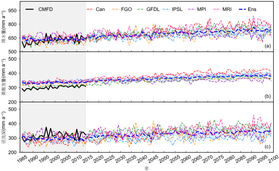
Fig. 1 Average annual precipitation (P), evapotranspiration (E), and runoff depth (R) change hydrograph for the Chinese mainland in 1985–2099 when the future scenario is SSP2-4.5; the solid line is the CMFD value, the thin dashed line is the simulated value of each model, the thick blue dashed line is the multi-GCM Ensemble (Ens) value, and the shaded area indicates 1 standard deviation of six GCMs data (see the figure attached to the article for the SSP5-8.5 scenario).
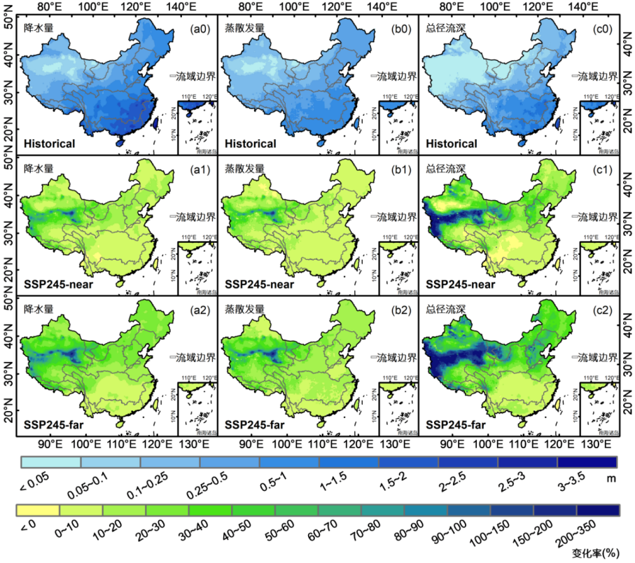
Fig. 2 The change rates (CR) of the multiyear average annual precipitation (P), annual evapotranspiration (E), and annual total runoff depth (R) of the GCM Ensemble in future periods under the SSP2-4.5 scenario relative to the historical period (1985-2014). (a)–(c) represent P, E, and R, respectively, and numbers 0–2 represent the historical period (Historical), the near future (SSP245-near), and the far future (SSP245-far), respectively (see the figure attached to the article for the SSP5-8.5 scenario).
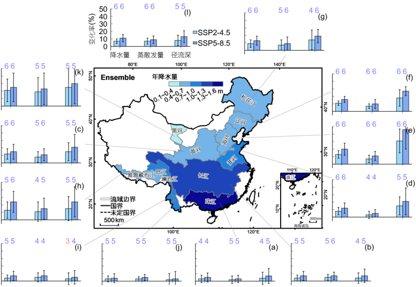
Fig. 3 The bias-corrected GCM Ensemble for the near future (2020–2049) multiyear average annual precipitation (P), annual evapotranspiration (E), and annual total runoff depth (R) change rates (CR) of the basins relative to the historical period (1985–2014), with error lines of 1 standard deviation for the six GCMs data. The number above the bar indicates the number of models with the same positive or negative CR of the variable as the Ensemble; the number not exceeding half of the total number of the models (<4) is red; otherwise, it is blue. (a)–(l) represent the following basins: PR, YZR, YR, Huai, HR, LR, SR, YZ, NR, LCR, Hei, and the Chinese mainland, respectively; the coordinate axes of (a)–(k) are the same as in (l). The color shades of the basins represent the magnitude of the multiyear average P in the historical period.
Different from the past conclusion based on the CMIP5 model that the runoff of China’s nine major basins is estimated to decrease, this study finds that future changes in annual precipitation using the latest and more reliable CMIP6 GCMs data, considering scenarios of future socioeconomic development, are very different from those considering only future radiative forcing changes, which may be the main reason for different projections of annual runoff (Fig. 4). The results of the study which may provide a strong scientific reference for future water resource management and risk analysis in China under climate change.
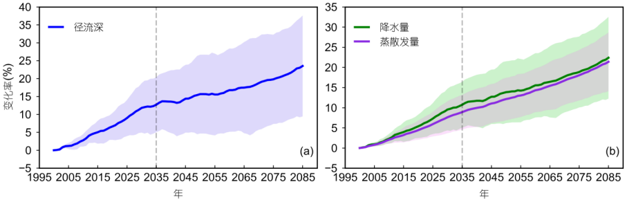
Fig. 4 GCM Ensemble CR in annual R (a) and annual P and E (b) throughout the 21st century for the Chinese mainland under the SSP5-8.5 scenario. The changes are calculated for every 30-year running average in the time series with respect to 1985–2014. Shaded areas indicate 1 standard deviation of the six GCMs data.
The related research results have been published in SCIENCE CHINA Earth Sciences as an article titled “Projection of China’s future runoff based on the CMIP6 mid-high warming scenarios”. Zhou Jiayue, a doctoral candidate of the DESS, Tsinghua University is the first author of the article, and her co-supervisor Associate Professor Lu Hui is the corresponding author. Other co-authors are from the DESS, Tsinghua University, the University of California, San Diego, the Changjiang Institute of Survey, Planning, Design and Research, and the China Institute of Water Resources and Hydropower Research. This work was supported by the Second Tibetan Plateau Scientific Expedition and Research Program (STEP) (Grant No. 2019QZKK0206), the National Key Research and Development Program of China (Grant No. 2017YFA0603703), the National Natural Science Foundation of China (Grant No. 4200011953), and the fundamental scientific research fund of China Institute of Water Resources and Hydropower Research (Grant No. JZ110145B0052021).
Article information:
Chinese version: 周嘉月, 卢麾, 阳坤, 江锐捷, 杨媛, 汪伟, 张学君. 2023. 基于CMIP6的中高温升情景对中国未来径流的预估. 中国科学: 地球科学, 53, doi: 10.1360/SSTe-2022-0065
English version: Zhou J, Lu H, Yang K, Jiang R, Yang Y, Wang W, Zhang X. 2023. Projection of China’s future runoff based on the CMIP6 mid-high warming scenarios. Science China Earth Sciences, https://doi.org/10.1007/s11430-022-1055-5
Full-text links:
Chinese: https://doi.org/10.1360/SSTe-2022-0065
English: https://doi.org/10.1007/s11430-022-1055-5
Written by Zhou Jiayue


 Picture News
 Hot News

