Nu-Salween River is an important international river that flows through China, Thailand and Myanmar, and also one of the few free-flowing rivers in the world without reservoir dams along the main stream. This basin is of high ecological value and great development potential, thus playing an increasingly important role in scientific research and local social and economic development. However, due to the complex climate and terrain in this basin and the lack of observation data, there is very few hydrological studies on the whole basin, especially the lower reaches of the basin outside China.
Recently, the research group led by Associate Professor Lu Hui from the Department of Earth System Science of Tsinghua University published a paper titled “Hydrological Characteristics and Changes in the Nu-Salween River Basin Revealed with Model-Based Reconstructed Data” in the Journal of Mountain Science. Based on the Geomorphology-based Hydrological Model (GBHM) and the reanalysis data with high spatial-temporal resolution, the paper reconstructs reliable hydrological data (GBHM-ERA5), reveals the historical hydrological characteristics and change trends of the lower reaches of the basin, and compares the hydrological differences among the upper, middle and lower reaches of the basin.
The research results show that in Nu-Salween River Basin, GBHM-ERA5 presents the highest consistency with observation data, and stable and reliable quality. Compared with the performance of global runoff dataset in Nu-Salween River Basin, GBHM has obvious advantages in simulation. It can make up for the shortage of data in this area and provide strong data support for the follow-up studies.
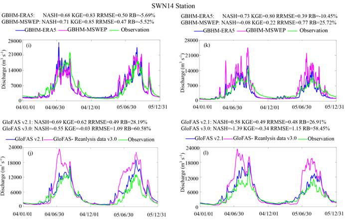
Fig. 1 Comparison of Observed and Simulated Flow at SWN14 Station in the Lower Reaches of Nu-Salween River Basin (NASH represents Nash-Sutcliffe coefficient; KGE represents Kling-Gupta coefficient; RRMSE represents relative root-mean-square error; RB represents relative bias)
According to the results of GBHM-ERA5 simulation, the spatial distribution of precipitation and surface runoff during the period from 1981 to 2014 is highly similar: the lowest in the upper reaches and the north of the middle reaches, the highest in the region of three parallel rivers in the middle reaches, and high in the south and north and low in the middle in the lower reaches. Affected by climate change, more than 70% of Nu-Salween River Basin saw a decline in surface runoff, especially in the region of three parallel rivers in the middle reaches, which showed a significant and rapid decline. In Nagqu County in the upper reaches and the area south of Shan State in Myanmar in the lower reaches, surface runoff showed a slight rise. The surface runoff from the upper reaches to the north of the middle reaches was greatly influenced by the temperature in winter and spring; the surface runoff in the south of the middle reaches was mainly controlled by precipitation; the surface runoff in the lower reaches was more affected by the temperature in dry season and by precipitation in rainy season. Due to the change of surface runoff, the runoff at the outlet of the upper reaches showed an insignificant rise, while that in the middle and lower reaches showed a significant decline. Besides, the runoff in the upper and lower reaches changed the most in summer, and that in the middle reaches dropped the most in autumn.
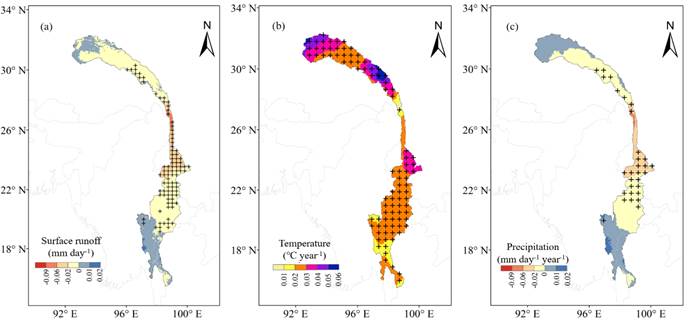
Fig. 2 Linear Trends of (a) Surface Runoff, (b) Temperature and (c) Precipitation in Nu-Salween River Basin from 1980 to 2018 (+ means that the results have passed the significance test at the confidence level of 95%)
This study can lay a scientific foundation for maintaining the sustainable development of the basin, help to deeply understand the influence of climate change on the hydrological process of the basin, and provide a basis for the data and method selection of follow-up studies. Further, this study can provide strong support for the formulation of policies on the sustainable utilization of water resources in the basin and for the scientific management of the basin, and promote multi-party cooperation to jointly maintain the harmonious and stable development of the basin and its surrounding areas. In addition, it can also provide a scientific basis for engineering development, and help decision makers to take targeted measures to deal with all kinds of water-related disasters.
Yang Fan, a doctorate student in the Department of Earth System Science of Tsinghua University, is the first author, and Associate Professor Lu Hui of the Department of Earth System Science of Tsinghua University is the correspondence author. The collaborators are from Tsinghua University, Sophia University, Changjiang Water Resources Commission, Ministry of Water Resources, etc. This study has received the support from the National Key R&D Program (2016YFA0601603), the Second Scientific Investigation and Research of Tibetan Plateau (2019QZKK0206), the National Natural Science Foundation of China (91747101 & 41801260) and the Strategic Priority Research Program of Chinese Academy of Sciences (XDA20100300). Besides, the computing resources of this study were provided by Tsinghua National Laboratory for Information Science and Technology.
Paper link:
https://link.springer.com/epdf/10.1007/s11629-021-6727-1
Contributed by: Yang Fan
Edited by: Wang Jiayin
Reviewed by: Lu Hui


 Picture News
 Hot News

