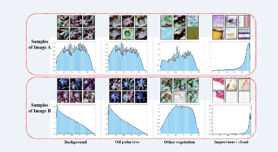
As an important tropical oil-producing crop, oil palm has high economic benefits and ecological research value. Accurate identification of oil palm is conducive to better management of oil palm plantations, thereby promoting the increase in palm oil production. Based on remote sensing images and deep learning models, there have been many researches that have achieved high-accuracy oil palm identification. But the existing work mainly focuses on a single, limited research area. When using different sensors, different times, and different regions of complex regional images, if directly use traditional models to make predictions, the accuracy of the oil palm detection results will be greatly reduced due to the obvious differences between the remote sensing images (Figure 1). At this time, if people want to maintain the recognition accuracy, they need to add new image samples to the recognition training, but this will require more manual labeling costs.

Figure 1. An example graph of the spectral difference between image A and image B for four different categories
Recently, Professor Fu Haohuan’s research group from the Department of Earth System Science (DESS) of Tsinghua University published a research paper titled Cross-regional oil palm tree counting and detection via a multi-level attention domain adaptation network in the ISPRS Journal of Photogrammetry and Remote Sensing, a high-impact journal in the field of remote sensing. . The research team designed a new domain-adaptive model, which increases the accuracy of oil palm recognition by 15% for brand new remote sensing image data and research areas without increasing the cost of labeling for new research areas. This method provides a reference for large-scale, cross-regional, and low-cost oil palm identification.
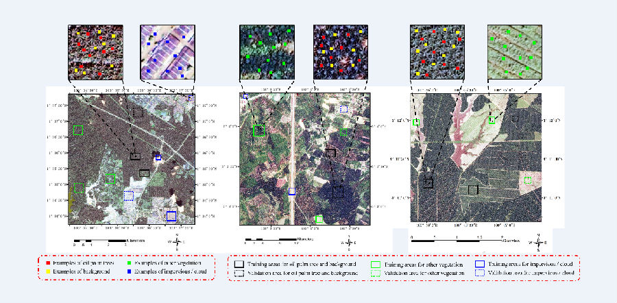
In order to further apply oil palm recognition to larger areas, Fu Haohuan's research group proposed a new Multi-level Attention Domain Adaptation Network (MADAN). This method does not need to relabel the samples of the target domain, only the samples of the source domain and the image information of the target domain. MADAN adopts a multi-level attention mechanism based on adversarial learning, which effectively measures the migration ability of different images and different regions of the same image, and greatly improves the confidence in the prediction of confusing samples in the target domain. The members of the research team took three different regions in Malaysia and their remote sensing images as examples (Figure 2) and found that MADAN achieved a significant improvement in accuracy of 3.55-14.49% compared with the latest existing methods.

Figure 2. Three different research areas. Area A (left) is QuickBird image, areas B (middle) and C (right) are Google Earth images.
Zheng Juepeng, a doctoral student in DESS of Tsinghua University, is the first author of the paper, and Li Weijia, a doctoral graduate of DESS and a postdoctoral researcher at the Chinese University of Hong Kong, is the corresponding author. Professor Fu Haohuan and Associate Professor Yu Le from DESS jointly directed the research work. This work was supported by the National Key Research and Development Program (No. 2017YFA0604500, 2017YFB0202204 and No.2017YFA0604401), the National Natural Science Foundation of China (No.51761135015 and U1839206) and the Pilot National Laboratory for Marine Science and Technology (Qingdao).
Paper link:https://doi.org/10.1016/j.isprsjprs.2020.07.002
Author: Liu Zhu research group
Reviewed by: Wu Haiping
Photo typesetting: Fu Meijuan