In April 2020, Yu Le's research group from DESS published a paper titled Annual oil palm plantation maps in Malaysia and Indonesia from 2001 to 2016 on Earth System Science Data, and released a set of 100m spatial resolution dataset of oil palm distribution year by year in Indonesia and Malaysia from 2001 to 2016.
Growing global demand for vegetable oils and biofuels in recent years has led to a dramatic expansion of oil palm plantations in southeast Asia, particularly in Malaysia and Indonesia, and the encroachment on the region's tropical forests. According to statistics, from 1990 to 2005, 50% of the new oil palm plantation area came from deforestation. In addition, oil palm expansion has caused biodiversity loss and increased greenhouse gas emissions. Quantitative analysis of the environmental impact caused by oil palm expansion requires a higher spatial and temporal resolution of the dynamic data set of oil palm land cover.
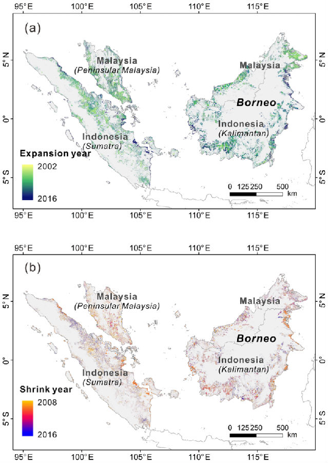
In this study, synthetic aperture radar data ALOS PALSAR, ALOS -2 PALSAR -2 and Moderate Resolution Imaging Spectroradiometer MODIS data set were used to obtain the first set of 100m annual oil palm distribution data sets in Indonesia and Malaysia from 2001 to 2016. Firstly, the global oil palm sample bank and random forest surveillance classifier established earlier were used to classify PALSAR data, and the distribution ranges of oil palm in 2007-2010 and 2015-2016 were obtained. Then, MODIS data and change detection algorithm were used to complete the change years in the missing years (2011-2014 and 2001-2006) to obtain the annual oil palm change data set. The accuracy evaluation based on the verification sample shows that the mapping accuracy and variation accuracy of the dataset are 86.61% and 75.74% respectively. The results show that the area of oil palm plantations in Malaysia and Indonesia increased by 146.60% and 322.46% respectively between 2001 and 2016. The data set can be further applied to regional carbon cycle, agricultural management, biodiversity conservation and sustainable development of the oil palm industry.
Xu Yidi, the PhD student of Yu Le's research group, is the first author of the paper, and Associate Professor Yu Le is the corresponding author of the paper. The collaborators include Professor Gong Peng, Associate Professor Li Wei, PhD student Cheng Yuqi from DESS of Tsinghua University, and Professor Philippe Ciais of the French institute for climate change and the environment. This research was supported by the National Key R&D Programs of China and Tsinghua University Project.
Original link:https://www.earth-syst-sci-data.net/12/847/2020/essd-12-847-2020.html
Data address:https://doi.org/10.5281/zenodo.3467071

Fig. 2001-2016 oil palm increase and decrease distribution map