Recently, DESS Ph.D. candidate Zhou Lu Zhou as the first author, Assistant Professor Xu Shiming as corresponding author published a paper online entitled “On the Retrieval of Sea Ice Thickness and Snow Depth using Concurrent Laser Altimetry and L-Band Remote Sensing Data” on The Cryosphere. This paper was also chosen as Highlight Article by The Cryosphere, which is about twelve articles ever year. The paper proposed innovative retrieval algorithm that combines high-resolution laser altimetry scans with the L-band radiometry satellite. With the proposed retrieval algorithm, both sea ice thickness and snow depth can be attained and the uncertainty for both sea ice parameters can be reduced contrast to existing algorithm.
Sea ice thickness and snow depth are vital parameters for polar hydrological cycle and also play important role in climate change analysis, the assimilation model and navigation. In conventional methods, large-scale sea ice thickness retrieval from altimetry satellite is restricted by the accuracy of snow depth. However, the current snow depth over the sea ice cover is mainly from climatology or reanalysis datasets. On one hand, these data can not mirror the latest Arctic snow condition and on the other, large uncertainty from the snow depth dominates the uncertainty of sea ice thickness and ice volume estimation.
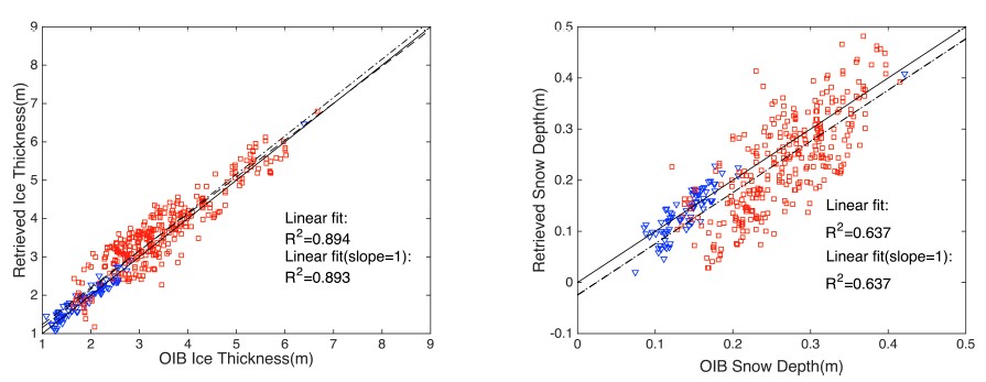
The paper combined sea ice radiation model and hydrostatic equilibrium for simultaneously retrieval for sea ice thickness and snow depth. According to large spatial resolution difference between laser altimeter and the passive microwave, the paper designed the spatial merged scheme. According to high-resolution observations, there is statistically significant covariability between the snow depth and the snow freeboard. This information of covariability is further incorporated in the retrieval algorithm, and it is demonstrated that the covariability plays a key role in the retrievability. Verification with available altimeter measurements from airborne and brightness temperature data from SMOS satellite shows that both sea ice thickness and snow depth can be retrieved, with the error in both parameters are under 15% and 25% respectively (Figure 1).

Figure 1. Validation based on OIB and SMOS. Sea ice thickness (left) and snow depth (right) are retrieved simultaneously. Blue and red dots are first-year ice and multi-year ice respectively[1].
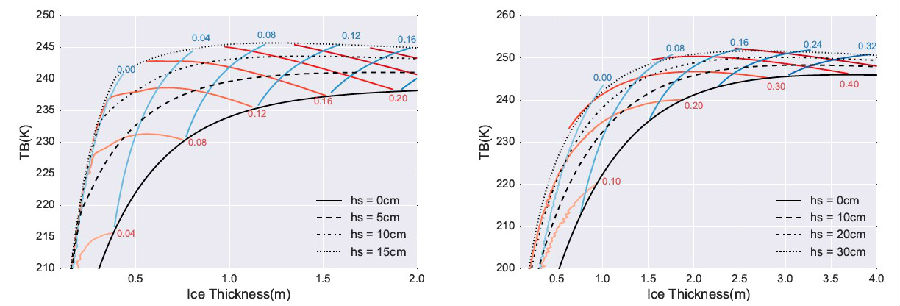
Recently, Xu Shiming research group published a number of papers online including the The Cryosphere and Remote sensing, proposing the combination of active and passive remote sensing data (Figure 2), while both parameters are retrieved and the uncertainty is further reduced. The algorithms can carry out the study of historical sea ice parameters analysis based on Cryosat-2, ICESat, SMOS and other satellites. It can also carry out in the future satellite platform (such as ICESat-2 and WCOM) for sea ice volume estimation, polar air-sea interaction, seasonal prediction, etc.

Figure 2. The principle for combined retrieval of altimetry and L-band microwave remote sensing. The saturation between the L-band bright temperature and sea ice parameter leads to the limitation of the retrieval, and the accuracy of combined retrieval can be improved effectively based on freeboard[2].
It is the first time that DESS published a paper as communication units in The Cryosphere, which is the authoritative magazine in the field of the cryosphere and its related climate change. And it is also the first time for Chinese scholar to obtain Highlight Article in this magazine. The impact factor for the journal in 2017 was 4.80, and the recent five-year averaged impact factor was 5.79.
Reference:
Lu Zhou, Shiming Xu*, Jiping Liu and Bin Wang. 2018.On the Retrieval of Sea Ice Thickness and Snow Depth using Concurrent Laser Altimetry and L-Band Remote Sensing Data, The Cryosphere, 12, 993–1012, doi:10.5194/tc-12-993-2018.
Shiming Xu*, Lu Zhou, Jiping Liu, Hui Lu and Bin Wang. 2017.Data synergy between altimetry and L-band passive microwave remote sensing for the retrieval of sea ice parameters - a theoretical study of methodology, Remote Sensing, 9(10):1079, doi:10.3390/rs9101079.
Lu Zhou, Shiming Xu*, Jiping Liu, Hui Lu and Bin Wang. 2017.Improving L-band radiation model and representation of small-scale variability to simulate brightness temperature of sea ice. International Journal of Remote Sensing, 38:23, 7070-7084, doi:10.1080/01431161.2017.1371862.