Recently, CESS Ph.D candidate Zhao Yuanyuan published a paper as the first author called"Detailed dynamic land cover mapping of Chile: Accuracy improvement by integrating multi-temporal data"on the journal of Remote Sensing of Environment.
Stretching over 4300 km north to south, Chile is a special country with complicated landscapes and rich biodiversity. Accurate and timely updated land cover map of Chile in detailed classification categories is highly demanded for many applications. A conclusive land cover map integrated from multi-seasonal mapping results and a seasonal dynamic map series were produced using Landsat 8 imagery mainly acquired in 2013 and 2014, supplemented by MODIS Enhanced Vegetation Index data, high resolution imagery on Google Earth, and Shuttle Radar Topography Mission DEM data. The overall accuracy is 80% for the integrated map at level 1 and 73% for level 2 based on independent validation data. Accuracies for seasonal map series were also assessed, which is around 70% for each season, greatly improved by integrated use of seasonal information. The importance of growing season imagery was proved in our analysis. The analysis of the spatial variation of accuracies among various ecoregions indicates that the accuracy for land cover mapping decreases gradually from central Chile to both north and south. More mapping efforts for those ecoregions are needed. In addition, the training dataset includes sample points spatially distributed in the whole country, temporally distributed throughout the year, and categorically encompassing all land cover types. This training dataset constitutes a universal sample set allowing us to map land cover from any Landsat 8 image acquired in Chile without additional ad hoc training sample collection.
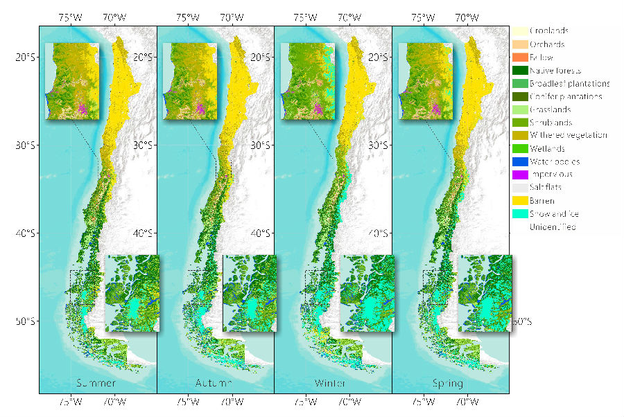
Fig.1 The seasonal land cover map series of Chile displayed at the level 1 (plus some level 2 classes) generalization.
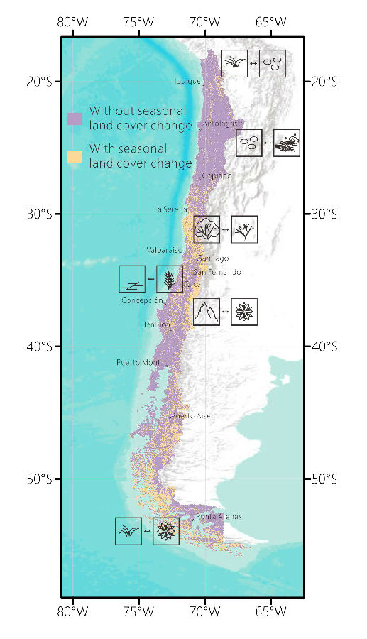
Fig.2 Distribution of area with seasonal land cover change and the major type of seasonal change.
According to Thomson Reuters Citation report in 2014, the impact factor of Remote Sensing of Environment is 6.393


 Picture News
 Hot News