China News Service, Beijing, August 24 (reporter: Guo Chaokai) learned on the 24th that Professor Gong Peng's research group from the Department of Earth System Science of Tsinghua University and the world's leading AI platform company SenseTime have recently jointly released a 3-meter resolution ground coverage mapping product. The land surface cover of the world mapping will be completed this year.
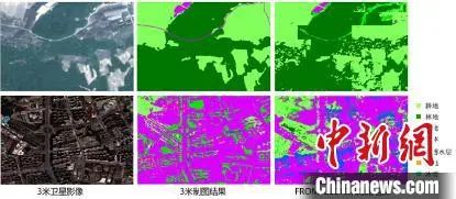
Comparison of the difference between the 3-meter map and the 10-meter map in Shanghai. Photo by SenseTime
This is a breakthrough achieved by Professor Gong Peng's research group and SenseTime in the field of global remote sensing mapping after 30-meter surface coverage mapping and 10-meter resolution global surface coverage mapping (FROM-GLC10). The result also represents the introduction of AI technology into the "high definition" era of remote sensing mapping.
With the intensification of human activities, the change of land information is also accelerating. In order to carry out more scientific and reasonable planning and implement the corresponding measures, fine land classification management is imperative. Therefore, it is particularly important to acquire the characteristics of the earth's surface in a timely and accurate manner and to carry out the research on global and regional surface information data. Under such a trend, the industry has put forward urgent demands for global land cover products with higher spatial resolution.
|
|
|
|
Based on the AI remote sensing intelligent interpretation deep learning algorithm, the 3-meter resolution surface coverage mapping product learns more than 50,000 102424 pixel images, using sample migration technology, the overall interpretation accuracy reaches 86%, and realizes the global natural environment, economic and social Interpretation of development. At the same time, thanks to the application of AI technology, efficient automatic processing of tens of thousands of high-pixel remote sensing images has changed from impossible to possible. The cross-domain "resonance" of AI technology and remote sensing technology has created a new development trend of remote sensing mapping.
Recently, the research group of Professor Gong Peng of the Department of Earth Sciences of Tsinghua University and the world's leading AI platform company SenseTime jointly released a 3-meter resolution land cover mapping product. Photo by SenseTime
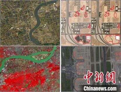
Experts said that the completion of the mapping of the 3-meter surface coverage will further accelerate related industries and applications, including the urban physical examination. In June this year, the Ministry of Housing and Urban-Rural Development issued the Letter on Supporting the Implementation of urban Physical Examination in 2020, carrying out urban physical examination in some cities, and a total of 36 cities were selected as sample cities for urban physical examination in 2020. As an innovative means of urban governance, urban physical examination is an effective means to support future high-quality urban development and fine management. The index of "ecological livability" mainly reflects the protection of various ecological environmental factors such as atmosphere, water and green space in a city. Based on the application of 3-meter surface cover mapping, combined with the multi-dimensional data support provided by the industry, it can provide scientific advice for government decision-making in multiple aspects such as ecological livability and transportation convenience.
Source: Chinanews.com

 Picture News
 Hot News

