Terraced fields are widely distributed in our country and have been an important carrier of agricultural production for thousands of years. In recent years, in order to more effectively prevent and control soil erosion, promote the restoration of national soil ecology and comprehensive land consolidation, the project of changing slopes into terraces has been developed, constructed and applied on a larger scale in vast mountainous areas. It is used in food security, water and soil resource conservation, and reformation of ecological environment. It has played a key role in improving, promoting human well-being and sustainable development. However, the current large-scale data on terraced fields in China is very scarce, the statistics on the area of terraced fields are incomplete and the timeliness is poor, and the data on the layout of national-scale terraced fields is even more difficult to obtain. Therefore, the development of terraced field mapping covering the whole China is extremely important for accurately reflecting the spatial distribution information of terraced fields, and it has great theoretical and practical significance for the scientific research and practical management of terraced fields.
Recently, YU Le’s research group from Department of Earth System Science of Tsinghua University published a paper titled "A 30 m terrace mapping in China using Landsat 8 imagery and digital elevation model based on the Google Earth Engine" inEarth System Science Data. The paper released the first 30m resolution data on the distribution of terraces in China, filling the gaps in large-scale terrace mapping.
The study used multi-temporal Landsat images and SRTM DEM data to construct an optimized feature set and sample set, formulated a reasonable and efficient classification strategy, and produced the first 30m resolution Chinese terraced field map. The overall accuracy of the mapping results reached 94%, and the kappa coefficient reached 0.72. The study revealed the spatial distribution and area information of my country's terraced fields in 2018. The mapping framework can be extended to large-scale terraced field mapping in other regions of the world. The mapping results can be applied to the fields of soil and water conservation, food security, biogeochemical cycle, biodiversity, and ecological service value evaluation. It can also be used for related research and basic data provided by management and decision-making basis.
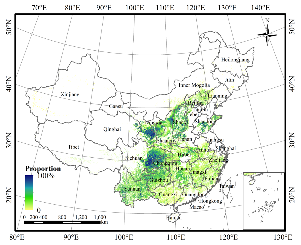
Image: Distribution of terraced fields in China in 2018
CAO Bowen, a doctoral student in Department of Earth System Science, Tsinghua University, is the first author of the paper, and Associate Professor YU Le is the corresponding author of the paper. Collaborators include Dr. Victoria Naipal from the University of Munich, Germany, Professor Philippe Ciais from the French Institute of Climate Change and Environment, Associate Professor LI Wei and Dr. LIU Zhuang from Tsinghua University, Associate Professor ZHAO Yuanyuan from China Agricultural University, Researcher WEI Wei and Post-doctor CHEN Die from the Research Center for Eco-Environmental Sciences, Chinese Academy of Sciences, and Professor GONG Peng of the University of Hong Kong. The research was supported by the national key research and development program.
Link of the paper:https://essd.copernicus.org/articles/13/2437/2021
Text: CAO Bowen
Editor: WANG Jiayin
Review: WU Haiping

 Picture News
 Hot News