In April 2019, Research Team led by Prof. Peng Gong published a paper in, titled“40-year (1978-2017) human settlement changes in China reflected by impervious surfaces from satellite remote sensing”.
Since 1978, China has undergone economic reform and rapid urbanization, accompanied with significant land cover change. Urbanization on such a large scale brought increasing problems and challenges for sustainable development. National-wide, high resolution observational land-cover data covering a long time period is thus desired for better urban planning and management, dealing with atmospheric and water pollutions, research on climate change and biodiversity. However, annual maps of impervious areas in China with high spatial details do not exist during this period.
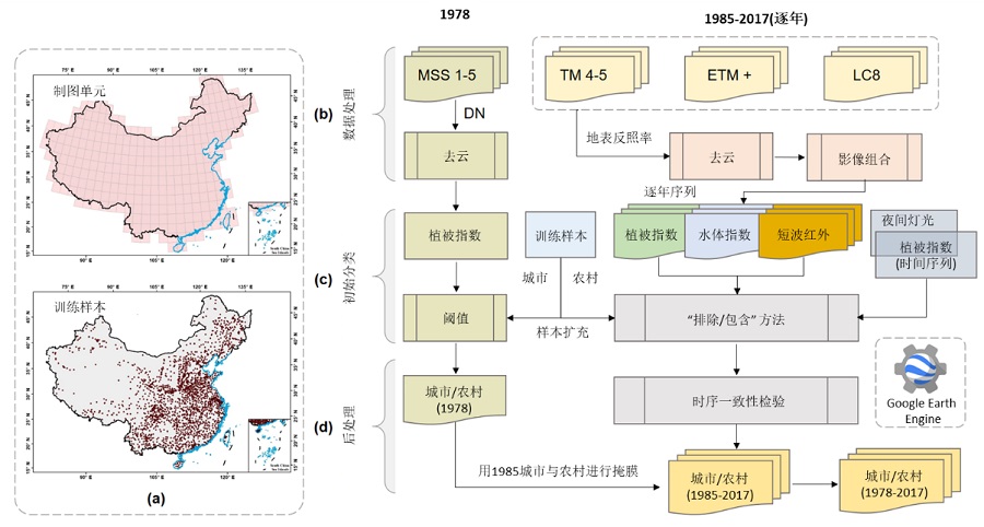
Professor Peng Gong’s research group developed the first annual human settlement map for China from 1985 to 2017 with a circa 1978 map, covering entire 40-year time span. China was divided China into 298 image grids, each with approximately 200?km?×?200?km in size. Inside each grid, training sample units in core-urban and rural areas based on Landsat observation in earlier years (1980s) were collected. Then the “Exclusion/Inclusion” algorithm was applied to generate initial maps of impervious surface in urban and surrounding rural areas. Finally, annual time series data of human settlements reflected by impervious surfaces were derived after implementing the temporal consistency check algorithm. All these algorithms were compiled in the Google Earth Engine (GEE) to ensure mapping efficiency at large scales.

Flowchart of mapping procedures in this study

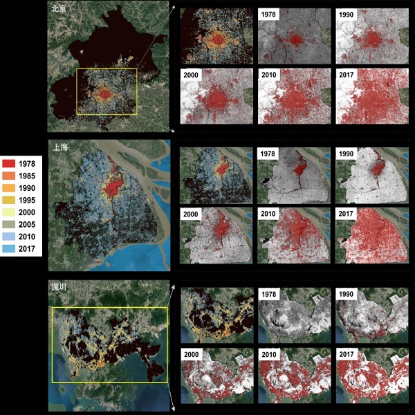
Illustration of extracted settlements for Beijing (a), Shanghai (b), and Shenzhen (c). Grey images in dotted frames are NDVI of different years overlaid settlement extraction in red
The accuracy assessment was based on manual interpretation of a long-term Normalized Difference Vegetation Index (NDVI) time series, local views of Landsat images, and high resolution Google Earth Images. Overall accuracies reached more than 90% for 30-m resolution data in 1985, 1990, 1995, 2000, 2005, 2010, and 2015. Spatio-temporal dynamics of both core-urban and rural areas are characterized in the product.
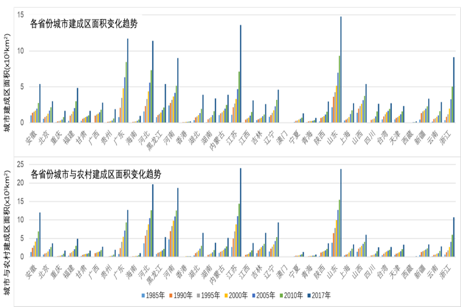
By 2017, the urban settlement areas reflected by impervious surfaces in China were 146,102?km2, while the urban and rural as a whole was 209,950?km2. The top urban expansion provinces are Shandong, Jiangsu, Hebei, Guangdong, and Henan, by 2017.

Settlement change trends from 1985 to 2017 by provinces
The growth trend of settlements will continue in China at a rapid pace before 2030. There is continuing needs for frequent monitoring of human settlement growth. It is important to incorporate new sources of data and explore new mapping algorithms. Only with consistently accurate, high resolution and frequent monitoring of human settlement areas can it be possible to meet the data needs in urban planning and management, beautiful and specialized village and township development, and many other applications including climate change, energy conservation, and environment protection in China. The framework developed here can be extended to mapping the entire world in the GEE platform.
The impervious surface data can be freely downloaded fromhttp://data.ess.tsinghua.edu.cn.
URLhttps://doi.org/10.1016/j.scib.2019.04.024