Longer time high-resolution, high-frequency, consistent, and more detailed land cover data are urgently needed in order to achieve sustainable development goals, and for the understanding, simulation and management of the Earth system. However, due to technological constraints, it is difficult to provide simultaneously high spatial resolution, high temporal frequency, and high quality observation data. Existing mapping solutions are limited by traditional remotely sensed data, that have shorter observation periods, poor spatio-temporal consistency and comparability. Therefore, a new mapping paradigm is needed.
On March 11, 2021, Professor Peng Gong’s group published a new research paper titled " Production of global daily seamless data cubes and quantification of global land cover change from 1985 to 2020 - iMap World 1.0” in Remote Sensing of Environment (Impact Factor: 9.085). It proposed a new generation of earth observation data and mapping solutions, developed the world’s first set of 1985~2020 30m global daily seamless data cubes (SDC) and global annual and seasonal land cover mapping data set, which fills the gap in large-scale, high-frequency, seamless remote sensing and mapping.
This paper developed a framework for intelligent mapping (iMap) of land cover based on state-of-the-art technologies such as cloud computing, artificial intelligence, virtual constellations, and spatio-temporal reconstruction and fusion. Under this framework, they built an automated, serverless, end-to-end data production chain and parallel mapping system with Amazon Web Services, providing the power for efficient transmission and processing of PB-level and nearly 5 million remote sensing images, and the support for the development of SDC and global land cover mapping.
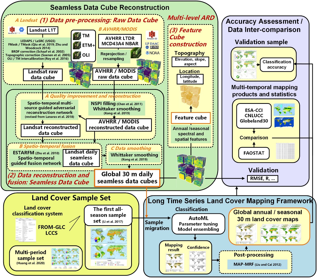
The framework for seamless data cube construction and global land cover mapping.
The SDC was produced through a multi-source spatio-temporal data reconstruction and fusion workflow based on Landsat, MODIS, and AVHRR virtual constellations. It is cloudless and seamless, improving the quality of remote sensing observations and is capable of reproducing complete spatio-temporal change time series. Independent validation results show that the relative mean error of the SDC is less than 2.14%. As analysis ready data (ARD) organized in the form of efficient and advanced Data Cube, it can be directly applied to various types of analysis.
From this SDC, we produced 36-year long, high-resolution, consistent global land cover maps by combining strategies of sample migration, machine learning, and spatio-temporal adjustment. The average overall accuracy of our annual land cover maps over multiple periods of time is 80% for level 1 classification and over 73% for level 2 classification (29 and 33 classes). Based on an objective validation sample consisting of FLUXNET sites, our map accuracy is 10% higher than that of existing global land cover datasets.
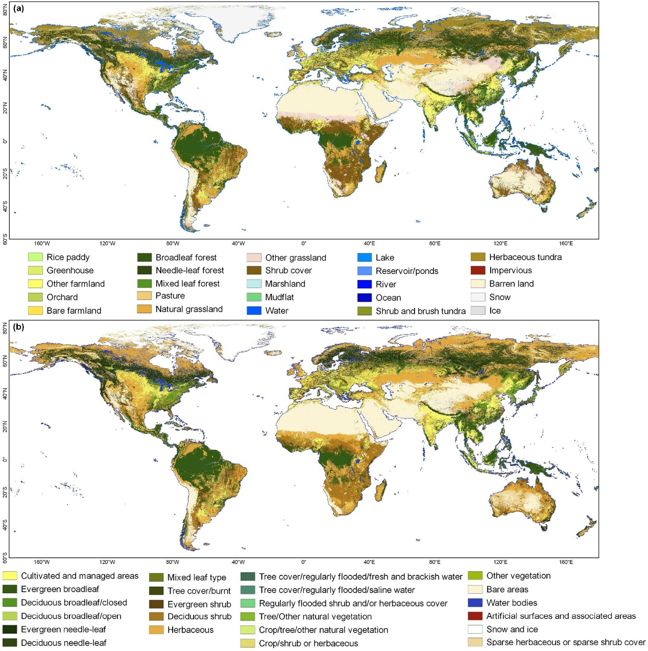
The global land cover map in 2020.
Our results show that the average global land cover change rate is 0.36%/yr. Global forest decreased by 1.47 million km2 from 38.44 million km2, cropland increased by 0.84 million km2 from 12.49 million km2 and impervious surface increased by 0.48 million km2 from 0.57 million km2 during 1985~2020.
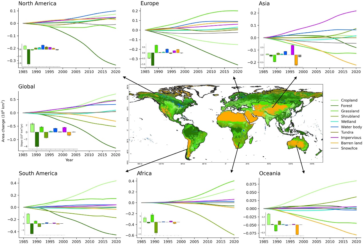
Global and regional land cover change and trend during 1985-2020.
This research not only realizes the efficient production of long-term daily seamless, near real-time land cover maps, and high-precision, unified-standard "analysis ready" remote sensing data sets, but also opens up the new paradigm for satellite remote sensing data processing and information extraction, which would greatly advance the application and development of remote sensing. In addition, the SDC and mapping results developed here can lay a foundation for high-precision quantitative remote sensing, and provide decision support for land resource management. It can be used as basic data for global environmental change research, and can support efforts towards achieving the United Nations Sustainable Development Goals.
PhD student Han Liu from the Department of Earth Sciences of Tsinghua University is the first author of the paper, Professor Peng Gong from the University of Hong Kong is the corresponding author, and Professor Bing Xu from the Department of Earth Sciences of Tsinghua University is a co-author. The collaborators also include Wang Jie, chief engineer of the Artificial Intelligence Earth Laboratory of Tsinghua Strait Research Institute, Wang Xi, assistant dean of Tsinghua Strait Research Institute, and Ning Qi of Sinnet Cloud Services Co., Ltd. The research was supported by the National Natural Science Foundation of China.
Link:
https://doi.org/10.1016/j.rse.2021.112364
Source: Department of Earth System Science

 Picture News
 Hot News